Showing posts with label Bas-relief. Show all posts

Friday, August 9, 2019

The Lost City of the Eagle


A mysterious Olmec presence in the Mixteca

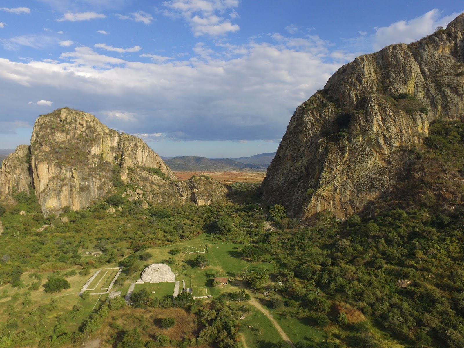
     Huehuepiaxtla is a small town located in the heart of the Mixteca region, 150 kilometers (100 miles) south of Puebla. Overlooking the town is a huge isolated peak, called by locals ‘La Peña’ – The rock. Tradition has it that the mountain was home to the first inhabitants of the region, who were later turned into stone by the gods.
The municipal president of Huehuepiaxtla, Dr. Florencio Dominguez (left) and our guide German (right) near a section of megalithic stone wall decorated with the image of an eagle on the summit of the Great Rock of Huehuepiaxtla [Photo by Author]
I first became interested in this mysterious site after coming across pictures online of what appeared to be several broken stelas and bas-reliefs [1]. There were also rumors of more extensive ruins near one of the peaks, including great stone walls and a broken obelisk. After contacting the local authorities, the municipal president Dr. Florencio Domínguez was kind enough to arrange for a guide and equipment to climb the peak and document whatever ruins we might find on top.

Upon arriving in Huehuepiaxtla, the summit of the Peña was still entirely shrouded in the morning mist. After the necessary preparations, we approached the cliff from the West. The peak now loomed directly a full 450 meters (1,470 ft) above us and the Rio Mixteco running below. Luckily, no rain had fallen in the past few days, so the rock was quite dry. Florencio explained that had it rained the night or the day before, the rock would have been too slippery to climb. Our guide, German, was an expert climber and one of very few people in town who know the difficult trail to the top.
The Great Rock of Huehuepiaxtla, as seen from the Mixtec River running below and around it. [Photo by Author]
Already at 10:00 am the temperature was nearly 30°C. Near the base of the cliff, we walked through a large flat area, trapezoidal in shape, which appeared to have been artificially leveled with steep embankments on all sides. Some overgrown mounds on the western side suggested this might have been a ceremonial plaza flanked by pyramids.

From there, a small trail led directly to the base of the cliff. Some steps and ledges had been originally carved in the rock, but these were now very worn. The path required to go through some very steep sections of exposed bedrock, which made the climb particularly difficult even in dry weather.
The steep trail leading up to the summit of the Rock of Huehuepiaxtla. [Photo by Author]
Another section of the difficult trail along the exposed cliff face, overlooking the village of Huehuepiaxtla and the Mixtec River below. [Photo by Author]
Along the trail we observed several pieces of obsidian and fragments of pottery. About half-way up, we passed through a set of terraces with massive stone retaining walls. The quality of the visible stonework varied, with some sections composed of huge, finely fitted rectangular stone blocks and others formed of rough boulders. The stone appeared to be a kind of basalt, which was probably sourced locally from the slopes of the great rock itself. 
Dr. Florencio holding a piece of obsidian, probably a small arrowhead, found along the trail to the summit. Note: No artifact was removed during the exploration, and all pieces were returned to their original location. [Photo by Author]
The handle of a broken ceramic vessel. Note: No artifact was removed during the exploration, and all pieces were returned to their original location. [Photo by Author] 
A partially exposed section of a megalithic stone wall about half-way towards the summit of the Great Rock. Some of the larger stones in the picture measure up to 3 meters (10 ft) long. The style of construction is reminiscent of Chimalacatlan and Huaxtla, two early Pre-Classic sites in the state of Morelos.[Photo by Author]
A retaining wall formed of large roughly shaped boulders laid without cement. [Photo by Author]
Some large broken sections of megalithic stone walls, like the one in the picture, suggest the existence of buried monumental structures on this side of the hill. [Photo by Author]
After some more climbing, we finally reached the summit at about noon. The summit consists in fact of a small, mostly level plateau or ridge in between two separate peaks, one to the East and the other to the West. This plateau contained extensive remains of ancient constructions and some overgrown mounds. However, the thick vegetation made it impossible to make out but the general outline of most of the structures.
The small cross located on one of the peaks of the Great Rock of Huehuepiaxtla, overlooking the town and the river below. [Photo by Author]
A rock ledge overlooking the Mixtec River 450 meters below. Note how the rock appears to have been artificially leveled and cut into steps. Several glyphs and rock carvings can be found in this area. [Photo by Author]
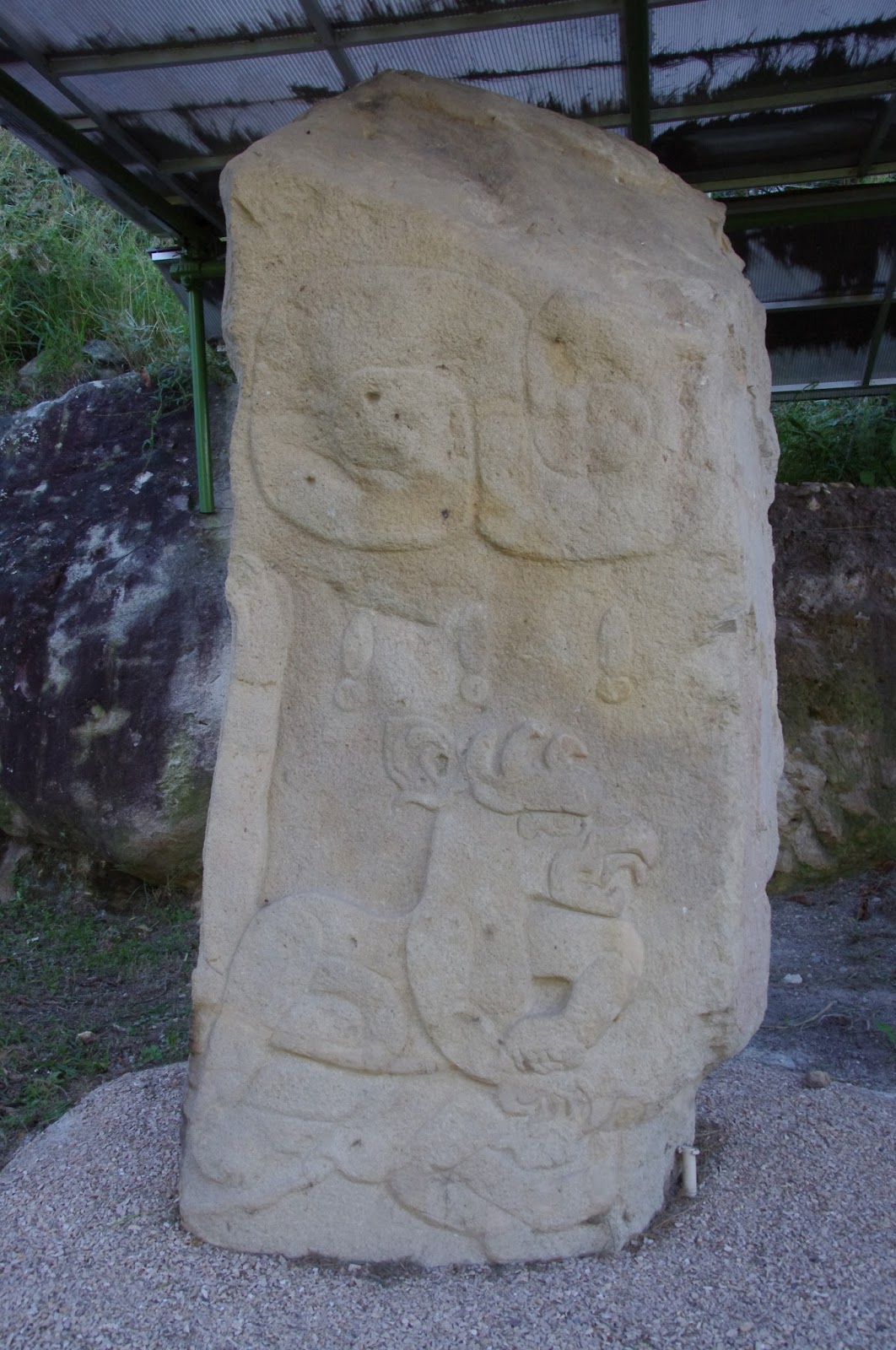
Opening our way with machetes through the thick undergrowth we reached the first of the two peaks, where a small cross has been erected that is visible from the town below. From there, it was possible to descend towards a rock ledge directly overlooking the river 450 meters (1,470 ft) below. The ledge appeared to have been artificially leveled and carved into steps or terraces, each just a few meters wide. Various glyphs and symbols were apparently carved on the rock, suggesting that this was in fact a very important point in the sacred geography of the area. Among the glyphs that we could make out were two apparent calendar symbols including the numeral ‘9’ and the figure of an eagle or vulture. The uppermost terrace, where the eagle bas-relief could be seen, was once delimited by a massive megalithic stone wall that emerged directly from the natural bedrock. The joints between the stones looked extremely tight, except for a point where some tree roots had partially dislodged a large vertical block. According to our guide, the peculiar arrangement of the stones around the eagle glyph indicated a hidden passageway. What made the existence of a passage through the rocks very likely was the presence of another bas-relief, depicting a crouching jaguar, which appeared to continue beyond the joint into the wall. From this point, it was also possible to see the entrance of another cave near the base of the cliff. Local traditions speak of vast subterraneans under the Peña. One of these is said to be covered in carvings and mysterious figures, but no entrance to these subterraneans is presently known.
A mysterious glyph on one of the rocks near the eagle carving. [Photo by Author]
A section of what appears to be a megalithic stone wall with the carving of an eagle and a calendar glyph with the numeral '9'. Note the peculiar arrangement of the stones to the right of the carving, allegedly concealing the entrance to a subterranean. [Photo by Author]
A close-up view of the eagle glyph on the same rock face. The figure of a jaguar can be faintly made out to the right of it. [Photo by Author]
Another glyph near the edge of the rock overlooking the Mixtec River some 450 meters below. The glyph is inscribed inside a circle and is also accompanied by the numeral '9', represented by a bar with four dots. [Photo by Author]
From this rock ledge, we continued along a trail overlooking the precipice in the direction of a small plateau separating the two peaks. There, in a small plaza facing an ancient overgrown pyramid lay one of the most fascinating monuments of antiquity in this parts of Mexico. It was a huge fallen stela, some 3 meters (10 ft) long, carved on one side with the image of an undefinable creature. It had slightly open legs, from which emerged what appeared to be a tail. Hands and feet looked like claws, but the creature appeared otherwise humanoid. The head could be that of a bat, with large pointed ears. The presence of clearly marked breasts suggested that the subject represented was a female. It was a unique type of stela, for the deeply embossed relief and the frontal depiction of the main figure. The stela was probably part of a pair that had been once erected in front of the main pyramid. Another fragmentary stela, now in the main square of Axutla, is also said to have been found at Huehuepiaxtla, and shows a very similar iconography. In this latter case, however, the figure depicted looks clearly human, possibly a dancer. The stela of Axutla is also significantly smaller, and the carving much shallower and less precise.
A large fallen stela in front of the main pyramid on the summit of the Great Rock of Huehuepiaxtla. The figure depicted is vaguely anthropomorphic, with claws in the place of hands and a curious head with pointed ears resembling a bat. [Photo by Author]
Another view of the same fallen stela with a smaller stone block that may have been its base or an offering table, also near the base of the main pyramid. [Photo by Author]
A view of what appears to be the main pyramid of the site, with its partially exposed stone core. [Photo by Author]
After passing the main pyramid, the trail led in the direction of the second peak. About half-way up towards the summit, we found a pair of strange megalithic arrangements. The first apparently consisted of some huge boulders, each probably weighting 1 ton or more, roughly piled up to form some sort of cairn about 3 meters (10 ft) high. A short distance from this first arrangement was a second one, consisting of even larger basalt columns stacked together as to form a fence. I found the resemblance to the famous Olmec megalithic tomb of La Venta particularly striking, especially for the use of prismatic basalt columns. From there, we entered another small plaza delimited on three sides by a stone wall. The wall had entirely collapsed, but the debris still reached up to 1 meter (3 ft) in height. The purpose of the wall was probably to delimit a sacred precinct in front of another very ruined pyramid that occupied the summit of the second peak. A large hole could be seen where a temple would have stood on top of the pyramid, probably dug by looters in search of treasure. From this vantage point it was possible to see at a distance of some 5 kilometers another giant rock, known as the Peña de Tlaxcuapan, where more ancient ruins are said to exist. 
A cairn formed of huge megalithic stone boulders on the summit of the Great Rock of Huehuepiaxtla. It is possible that these stones once formed part of some large fallen structure. [Photo by Author]
A curious megalithic arrangement consisting of several basalt columns, each up to 3 meters (10 ft) high. This is reminiscent of the famous Olmec tomb of La Venta, probably early Pre-Classic. [Photo by Author]
A view of the Rock of Tlaxcuapan from the summit of small pyramid that occupies the second peak of the Great Rock of Huehuepiaxtla. [Photo by Author]
We then began a difficult descent along a small overgrown pathway towards a spot where our guide German claimed a huge broken stela or obelisk could be found. After a turn, we found ourselves in front of an immense stone wall, formed of huge megalithic blocks up to 4 meters (13 ft) long, laid in regular courses without mortar or cement. The wall apparently formed the side of a large stone platform or terrace, on top of which rose a second platform also lined with great megalithic stones. The overall impression was one of extraordinary antiquity. Near the base of the lower platform we found another curious arrangement of basalt columns, each probably 3 or 4 meters  (10-13 ft) long, placed horizontally as to form a kind of bridge. We could not determine whether the columns actually formed part of the roof of some buried structure, but this seemed very likely. A short distance from there we reached the ‘Stone of Sacrifice’. This was in fact an enormous broken stela, which may have stood up to 6 meters (20 ft) tall when still erect, but which now lay broken in four parts. The decoration on the stela betrayed a clear Olmec influence. Although now badly defaced, it probably depicted a ruler crowned by what appeared to be a very elaborate headdress.
A set of huge monolithic basalt columns laid horizontally as to form a sort of bridge, possibly the roof of a tomb. [Photo by Author]
A section of a massive megalithic wall forming the side of a terrace. Some of the stones pictured above measure over 3 meters (10 ft) long, with a weight of several tons. [Photo by Author]
Another view of the same megalithic terrace, formed of massive prismatic basalt columns laid in rows without mortar or cement. Probably early Pre-Classic. [Photo by Author]
More ruined megalithic stone walls, partially covered by vegetation. [Photo by Author]
A view of some other megalithic structures on the upper terrace, also built of huge blocks of prismatic basalt laid without mortar or cement. [Photo by Author]
The great broken stela known as the 'Stone of Sacrifice' at the base of the lower terrace. The fragment on the left shows a badly eroded head and torso, while the larger fragment on the right contains part of an elaborate headdress. The style of the sculpture is typically Olmec. When erect, the stela (now broken in at least four pieces) would have stood at least 6 meters (21 ft) tall. [Photo by Author]
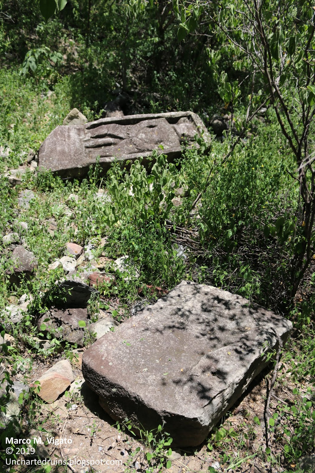
More Olmec-style carvings could be found near the base of the Peña. These appeared to have also been part of another large broken stela. A glyph accompanied by the numeral ‘4’ could be seen on one of the fragments.
Fragments of a large broken stela found near the base of the Rock of Huehuepiaxtla. A glyph with the numeral '4' can be clearly made out in the center of the picture. [Photo by Author]
More fragments of the same broken stela, with apparently Olmec carvings. [Photo by Author]
The rock of Huehuepiaxtla was certainly a very important site in ancient times, and it is a pity that so little is known about it. Everything suggests that this was a major ceremonial center in the Pre-Classic period, probably as early as 1,000 B.C., and may be related to the other Olmec sites in the region, at Chalcatzingo, Chimalacatlan, Huaxtla, Teopantecuanitlán and Juxtlahuaca.

The possibility of a connection between these sites is further suggested by the fact that a line drawn through Chimalacatlán and Huaxtla (as described in a previous article [2]) leads directly to the rock of Huehuepiaxtla. A continuation of the same line crosses the nearby rock of Tlaxcuapan and ends at Apoala. This alignment of five sites, all displaying unusual megalithic architecture, appears to be hardly coincidental.
It is only to be hoped that the Mexican Institute of History and Anthropology (INAH) also gathers an interest in this now forgotten site and helps preserve it from looting for the benefit of future generations.  
A herd bathing in the Mixtec River, at the base of the Great Rock of Huehuepiaxtla. [Photo by Author]
Another view of the Rock of Huehuepiaxtla, standing in monumental isolation in the hilly landscape of the Mixteca. [Photo by Author]
Part of a broken stela, allegedly from Huehuepiaxtla, found in the main square of the town of Axutla. [Photo by Author]
Another stone fragment in the main square of Axutla, possibly from the same stela. [Photo by Author]
References

Unfortunately, no bibliography could be found concerning Huehuepiaxtla and its ruins, as the site is presently unpublished and no mention of it exists in academic literature. 

[1] La Gran Peña, origen de mitos y leyendas en la Mixteca poblana y oaxaqueña, in MunicipiosPuebla.mx, December 22, 2013 – On-line resource: http://municipiospuebla.mx/nota/2013-12-22/acatl%C3%A1n-de-osorio/la-gran-pe%C3%B1a-origen-de-mitos-y-leyendas-en-la-mixteca-poblana-y

[2] Marco M. Vigato, Tamoanchan, in Search of the Lost Cradle of Mesoamerican Civilizations, in Ancient Origins, February 9, 2019 – On-line resource:https://www.ancient-origins.net/ancient-places-americas/tamoanchan-0011452

Also on this blog: The Location of the Mesoamerican ‘Hall of Records’ at Chalcatzingo: http://unchartedruins.blogspot.com/2016/11/the-location-of-mesoamerican-hall-of.html - Note the striking similarity between the profile of the rock of Chalcatzingo and the Peña of Huehuepiaxtla, as if to suggest that these may have in fact been sister sites belonging to the same culture

Monday, November 21, 2016

The location of the Mesoamerican "Hall of Records" at Chalcatzingo

Legends of the "Hall of Records"
The ancient site of Chalcatzingo from the air - perched between the two hills of Cerro Chalcatzingo (to the left) and Cerro Delgado (to the right) [Photo by Author]
      Esoteric traditions dating back at least to the ancient Greeks and Romans talk about the existence of vast repositories of knowledge dating back to antediluvian times. In more recent times, American mystic Edgar Cayce (also called “the sleeping prophet” for his readings dictated while in a state of trance) became famous for his “Atlantean” readings describing the existence of at least three different “Halls of Records” in different parts of the world. Of these, one was located in Egypt, in the vicinity of the Great Pyramid of Giza; another was located on the island of Atlantis itself and a third in Central America or Yucatan.

The search for the Mesoamerican hall of records has led enthusiasts and independent researchers far into the forests of Yucatan and Guatemala. The remote site of Piedras Negras, in present day Guatemala, is often considered to be the most likely location of the elusive Atlantean records, and has also been the subject of a recent DVD documentary trying to demonstrate the existence of buried structures and an ancient cave system at the site.  

Arrival of the Gods

     Ancient Mesoamerican traditions do indeed describe the arrival of bearded, white-skinned “Gods” from across the Ocean, the most famous being perhaps Quetzalcoatl. Just as in the Atlantean tradition, these “Gods” were responsible for bringing the gifts of civilization to the savage and yet uncivilized people of Mesoamerica. They were the inventor of writing and the calendar, of monumental stone architecture and of all the arts and sciences. Finally, they left, leaving behind a few of their race who would later become the first divine kings of the Mayas and the Toltecs. Upon leaving, the gods carried with them their sacred writings and their most prized relics. According to another legend, they buried great treasures beneath the earth, in caves and other secret places – so that they would one day recover them upon their return.  

The earliest known depiction of the feathered serpent in Mesoamerican Art, dating from 1,200-800 BC - from Monument 19 of La Venta (National Museum of Anthropology, Mexico City) [Photo by Author]
The earliest depiction of Quetzalcoatl, the “feathered serpent” is found among the Olmecs. The famous Monument 19 of La Venta – now in the National Museum of Anthropology in Mexico City – depicts a man with a helmet, sitting within the coils of a serpent and carrying what appears to be a “handbag”, curiously identical to artistic representations of “handbags” carried by gods in Mesopotamian art. Monument 19 dates to between 1,200 and 800 BC, and is therefore one of the oldest monumental expressions of Mesoamerican stone sculpture.  

The Olmecs were the first major civilization in what is today Mexico and Guatemala, flourishing during a period called by archaeologists the Formative Period of Mesoamerica, dating from 1,500 BC to 400 BC. The Olmec heartland was located in the tropical lowlands of the present-day states of Veracruz and Tabasco, along the coast of the Gulf of Mexico. 
The Olmecs have left few, enigmatic monuments, the most famous being perhaps the colossal stone heads unearthed during the 19th and 20th century, together with some of the finest examples of stone sculpture in the entire American continent.

Chalcatzingo

     Chalcatzingo represents an anomaly in Mesoamerican archaeology. For its location in the Central highlands of Mexico, several hundred miles from the Olmec heartland, it contains the most impressive set of Olmec monumental sculpture and rock art anywhere outside of the Olmec capital at La Venta. It becomes immediately clear that the exceptional importance of Chalcatzingo must have been predominantly of a ritual or religious nature. The relatively small dimension of the formative period settlement, hosting an estimate of between five hundred and a thousand people, contrasts with the richness of the decorative art at the site and the large number of sculptured stone monuments.
Another view of Chalcatzingo from the air - The Cerro Delgado in the foreground and the almost perfect pyramid-shape of the Cerro del Chumil in the foreground. The main ceremonial center includes a large plaza surrounded by pyramids and platforms, a ballcourt and a sunken patio. [Photo by Author]
A closer view of the main ceremonial area from the air, against the backdrop of the Cerro Delgado [Photo by Author]
The ancient settlement is nestled in a plain at the base of two high hills, the Cerro Chalcatzingo and the Cerro Delgado. The largest groups of bas-reliefs is found on the cliff face and on some large fallen stone boulders at the base of the Cerro Chalcatzingo, with several others occurring on isolated stone slabs and stelae within the ceremonial center proper.

The most famous rock-cut monument at Chalcatzingo, Monument no.1, is also known, as “El Rey” – ‘The King´. It is found on a high rocky outcrop, less than a quarter of the distance from the base of the Cerro Chalcatzingo. The bas-relief depicts a crowned human-like figure, dressed ornately and sitting on a throne. Most interestingly, the figure is placed inside a cave, from which issue forth strange volutes of what might be wind or mist. The cave is shown in profile, and has the aspect of an open mouth surmounted by an eye. Large clouds are pictured above the cave, with exclamation-like (!) objects falling from them, together with what might be interpreted as symbols for lightning or thunder. The seated figure inside the cave carries a bundle of what appear to be scrolls.

Monument No.1 of Chalcatzingo, depicting the "God of the Mountain" sitting inside a cave in profile, from which a wind appears to blow. The seated figure is carrying a bundle of what appear to be scrolls. Note also the eye above the mouth of the cave, which makes it resemble the open jaws of the Earth monster. [Photo by Author]
The same cave is represented on Monument no.9, this time from a frontal point of view. The cave has a quatrefoil opening, with a large hole in the middle corresponding to the cave entrance, above which are two eyes similar to the iconography of Monument no.1.
The same cave depicted on Monument No.1, now portrayed from a frontal point of view. Note the curious and artificial-looking quatrefoil opening in the middle, corresponding to the open mouth of the Earth monster (Cast in the National Museum of Anthropology, Mexico City) [Photo by Author]
The figure of a Gryphon attacking a man on a loose stela found near the base of the Cerro Chalcatzingo. Note the exclamation signs (!) above the figure, probably representing large drops of rain. [Photo by Author] 
Another fragmentary monument (Monument no. 13) at the base of the hill shows, in the remaining portion, the same cave entrance with a figure, probably a priest, sitting inside it.  

Two more monuments among the over 40 present on the site are interesting for the purpose of our research. One, labelled Monument no. 21 depicts a woman in profile, standing next to a large rectangular object of unknown significance. The object appears to be a large pillar or obelisk, wrapped and covered in intricate designs. The object stands on a kind of platform, to which it seems to be attached. The platform encloses a square space with a diamond shape in the center and an opening in the middle. A similar scene is also portrayed on Monument no.32, this time representing a man mirroring the same gestures of the woman on Monument no. 21.

The monument marked no. 2, show a procession of elaborately clad personages wearing Olmec-style masks. Three figures are standing, brandishing what could be maces or torches, while a fourth figure is laying on the ground. This last figure is the most interesting, for it appears to be bearded and carries an elaborate headdress. It is unclear whether this is the depiction of a deceased or a bound prisoner.

A number of other carvings show serpents, jaguars attacking men (curiously depicted with a beak, which gives them the appearance of Gryphons, a subject otherwise unknown in Mesoamerican art), and an equally curious representation of a man wearing a helmet, who is either swimming or flying – attributes for which it has been aptly named “El Volador”.
The main pyramid-platform in the ceremonial center of Chalcatzingo, with the Cerro Delgado in the background. At its apex, the site had a population of between 500 and a thousand individuals [Photo by Author]
The spectacular landscape of Chalcatzingo, characterized by the remarkable alignment of three mountains, the Cerro Chalcatzingo (in the foreground, left), the Cerro Delgado and the almost perfectly pyramid-shaped Cerro del Chumil (in the background). The volcano Popocatepetl is hidden by clouds. [Photo by Author]

The siting of some of the bas-reliefs on large boulders apparently fallen from the cliff-face of the Cerro Chalcatzingo in the background [Photo by Author]

More of the curious rock carvings found on boulders around the base of the Cerro Chalcatzingo, believed to depict cosmogonical scenes related to the Creation of Man. [Photo by Author]
A secret cavern?

     For the extreme importance attributed to sacred caves in Chalcatzingo art, not a single significant cave is known in the Cerro Chalcatzingo or the neighboring Cerro Delgado. Both mountains represent singular geologic anomalies in an otherwise predominantly flat landscape. Their composition is a reddish porphyry, extremely hard and compact. Seen from a distance, together with the nearby Cerro del Chumil, they have the aspect of massive natural pyramids rising almost unnaturally from the plains of Morelos.

Because of the type of rock of which the Cerro Chalcatzingo and the nearby Cerro Delgado are composed, the presence of natural caves in their interior is extremely unlikely. It is, however, the peculiar way the cave entrance is depicted on the Chalcatzingo monuments and rock carvings that suggests we may not here be dealing with a natural cavern, but rather with an artificial tunnel or vault. The regular, quatrefoil shape of the cavern mouth, together with the other depictions of what appears to be a square or rectangular enclosure, are suggestive of an artificial space rather than a natural one.    
The impressive view from the summit of the Cerro Chalcatzingo, looking towards the Cerro Delgado (below) and the almost perfect pyramid shape of the Cerro del Chumil in the distance. Rising almost unnaturally from the level plain, these isolated peaks, which are moreover found in a perfect alignment to each other, represented places of natural sanctity for the early inhabitants of the Central Mexican highlands and might have inspired some of their earliest creation stories. [Photo by Author]
The figure of “El Rey” depicted on Monument no.1 sitting inside the cavern, further hints to the possibility that documents of some sort, together with “scrolls” and other sacred relics might have been buried inside the cavern. Additionally, the cave might have contained the burial of a very high-ranking individual of the Olmec or pre-Olmec elite.  

Another interesting parallel can be drawn between the carvings representing men being attacked and killed by jaguars, the references to rain in the form of clouds with rain drops and lightning, and the Mesoamerican creation myths. According to these early creation accounts, humanity had suffered at least four previous destructions, in which people were devoured by jaguars or drowned in a deluge. All of this seems to find a parallel in the strange rock-carvings of Chalcatzingo, which, according to several interpretations, might have been intended as an account of creation.

It is certainly suggestive to imagine the cave, surmounted by ominous clouds, as a sort of antediluvian shelter where documents and other artifacts were preserved from the coming deluge by a previous human race.
The strange, almost ´technological´ aspect of some of the objects displayed on the bas-reliefs, particularly the two bound pillars or obelisks portrayed on Monument no. 21 and on Monument no. 32, also seem to be related to the content of the cavern, particularly if the square enclosure depicted at the base of both monuments and is to be interpreted as a stylized cave or Earth monster.
Artist rendition of Monument No.1 of Chalcatzingo, known as "El Rey". One can appreciate both the cave (seen in profile) and the clouds pouring rain from above. 
The carvings on Monument No. 2, depicting a procession of masked men carrying maces or torches and a bearded individual lying on the ground.
Monument No. 21 of Chalcatzingo, depicting a woman touching a rectangular object of unknown significance, which could represent a bound pillar or stela, standing on top of a rectangular enclosure with an opening leading to a diamond-shape in the middle. 
Where, then, was this cavern located?
There are three possible locations for the cave entrance, two on the Cerro Chalcatzingo itself, and one on the nearby Cerro Delgado.  

The most obvious location would be on one side of the bas-relief known as “El Rey” or Monument no.1. There seem to be several large boulders on this spot covering what might be the entrance to a cavern, including parts of the bas-relief itself. The ground there is very humid, which might suggest the presence of a natural water source. There is moreover evidence of fairly recent excavations on the opposite side of the trench in which the bas-reliefs are located. If a cave existed at this spot, it has either collapsed or was covered by debris fallen from the cliff face in ancient times.   
The position of Monument No.1, known as "El Rey" (to the left of the picture), next to what could be the entrance of a collapsed cavern filled with large boulders. [Photo by Author]
A second location could be high up on the Cerro Chalcatzingo, where a rock ledge exists in the cliff face about one quarter of the distance to the summit. The position of this ledge on the almost vertical cliff-face and at an height of over 200 meters over the valley floor makes any exploration attempt almost impossible. The best piece of evidence for the existence of a cave or a yet undiscovered group of bas-reliefs on this spot is the fact that almost all of the rock carvings at the base of the Cerro Chalcatzingo are found on enormous rock boulders that must have detached from the mountain itself. Because of their position, it is very well possible that some of the bas-reliefs originally formed part of a continuous frieze located near the summit of the mountain, whose collapse left only the rock ledge which is still visible exposed.  
A view of the Cerro Delgado from the sunken patio in the main ceremonial area of Chalcatzingo. The profile of a monstruous face with two open eyes, nose and mouth can be made out on the rocks near the summit. [Photo by Author] 
A final possibility is that the cave entrance could be located not on the Cerro Chalcatzingo, but on the nearby Cerro Delgado. Pictures of the cliff face taken with the aid of a drone, do indeed reveal what might be cave openings very near the summit, in a location of almost impossible access. What is most intriguing about these possible cave openings is that they are strongly reminiscent, under certain light conditions, of the eyes and mouth of a giant monstrous face. This might explain the eyes placed around the mouth of the cave on the Chalcatzingo bas-reliefs. 
Could this be the reason why the site was also chosen by the Olmecs for realizing one of their most impressive settlements and artistic displays, so far from their cultural heartland on the Gulf Coast of Mexico? More research will be needed to confirm the existence of a cave entrance on the precise spot corresponding to the “mouth” of the Earth monster carved on the face of the Cerro Delgado.
A closer view of the Cerro Delgado from the air, near sunset. The oblique sunlight makes visible the entrance of some shallow caves near the summit of the mountain that curiously resemble the eyes depicted above the cave entrance on the two most famous Chalcatzingo monuments. If this interpretation is correct, the cave entrance may be found on the rock ledger where the "mouth" of the Earth monster is supposed to be. [Photo by Author] 
The discovery of this cavern might perhaps reveal more of the mysterious origins of the Olmec people and of Mesoamerican civilization as a legacy of the “Gods”.

A drone fly-over of the ancient site of Chalcatzingo and the nearby Cerro Delgado [Video by Author]: 

References:

[1] Chalcatzingo Archaeological Site – From Wikipedia:  https://en.wikipedia.org/wiki/Chalcatzingo
[2] David C. Grove, Ancient Chalcatzingo, University of Texas Press, Austin, 1987 – Online resource: http://www.famsi.org/research/grove/chalcatzingo/index.html
[3] Museum entry on Chalcatzingo, Morelos – National Museum of Anthropology,  Mexico City: http://www.mna.inah.gob.mx/coleccion/huellas-mna/anteriores/chalcatzingo-morelos.html