Showing posts with label Morelos. Show all posts

Monday, May 25, 2020

Tamoanchan - Cradle of Mesoamerican civilization?


In search of a Lost Cradle

                The oldest Nahua legends speak of a mythical place called Tamoanchan, considered to be the cradle of all Mesoamerican civilizations and a sort of terrestrial paradise from which the ancestors of the Aztecs and the Toltecs would go out to repopulate the earth after a great Flood. According to the early colonial historian Bernardino de Sahagún (1500-1590 AD), the original inhabitants of Tamoanchan had come from the Sea: “They say the came to this land to rule over it…they came from the sea on ships, a multitude of them, and landed on the shore of the sea, to the North…from there they went on, seeking the white mountains, the smoky mountains…led by their priests and by the voice of their gods. Finally, they came to the place that they called Tamoanchan…and there they settled [1].” These learned men invented the sacred books, the count of destiny, the book of years and the book of dreams. Tamoanchan has been since identified with a number of places in ancient Mexico, including Tula and Teotihuacan, but these are likely later associations from a time when its true location had already become lost and shrouded in legend. 

The oldest Mesoamerican Civilization

The earliest historical traditions locate Tamoanchan far from the coast, in the province of Cuauhnahuac near present-day Cuernavaca. From there, the tribes that would become the ancestors of all later Mesoamerican civilizations spread to the North, East and South to give rise to the civilizations of the Toltecs, the Olmecs and the Maya. These people called themselves the Chan, the “People of the Serpent”, and the very name of Tamoanchan may have come from them [2].
In 1911, the bishop of Cuernavaca, Francisco Plancarte y Navarrete formulated a theory that Tamoanchan was once a real place, whose ruins were to be found in the Southern part of the state of Morelos. He believed that the civilization of Tamoanchan was older even than that of the Olmecs and had spread throughout Mesoamerica from a single point of origin. A few years earlier, Plancarte had collected rumors of the discovery of immense stone ruins in the remote mountains of the Sierra de Huautla, to the South of Cuernavaca, which he believed could point to the location of Tamoanchan. These ruins were of a cyclopean kind, entirely different from the crude constructions of the Aztecs and of an antiquity so remote that no record of their builders had survived in the records of the Conquest.
A corner at the base of the megalithic ramparts of Chimalacatlan, where the walls rise to a height of nearly 10 meters (33 ft). The foundations of the walls rest directly on the natural bedrock, making a precise dating of these structures extremely problematic. [Photo by Author] 
A view of the great megalithic walls surrounding the Acropolis of Chimalacatlan. Some of the stones measure over 3 meters long, with an estimated weight of between 5 to 8 tons [Photo by Author]
“A most ancient and famous work”

The ruins were again rediscovered in 1948 by the archaeologist Florencia Müller, who similarly considered them to be of very great antiquity. In the absence of datable remains, she tentatively attributed them to the Olmecs, whose presence in the region is attested since at least 1,200 B.C. [3] The largest structures were located near the village of Chimalacatlan and consisted of a number of megalithic stone platforms occupying the artificially-leveled summit of the Cerro del Venado. The walls survived up to a height of nearly 8 meters in certain points and were built of huge blocks of stone measuring up to 3 meters long, laid in regular rows without mortar. Immense efforts had certainly gone into the construction of the massive walls and terraces, yet no trace could be found of the original builders and inhabitants. The only ceramic and a few tombs found at the site dated to a much later period than that of the construction of the walls. Nor was there any trace of the structures that were intended to be built on top of the megalithic platforms.
One large stone platform measured some 40 by 30 meters and would have once contained a sunken courtyard also lined with megalithic stone blocks. A partially carved rock surface and some giant monoliths on the upper terraces of the site are all that remains of a great unfinished structure that may have been a temple. Some of the stones that had been prepared for the construction, only partially detached from the natural bedrock, would have weighted as many as 20 tons. A number of cylindrical column shafts, each measuring about 2.5 meters long, were also found nearby. More constructions were certainly planned near the summit of the hill, where the rock was artificially flattened and carved, but these were either dismantled or were never built. Even so, the ruins of Chimalacatlan are not only the largest and best-preserved examples of cyclopean megalithic architecture in all of Mesoamerica, but also quite possibly the oldest.   
The wall of the upper terrace on the Acropolis of Chimalacatlan, built of large megalithic stone blocks. The top of the lower platform contains a large sunken courtyard that has not been excavated. [Photo by Author]
Another view of the Northwest corner in the lower platform walls of Chimalacatlan, preserved to a height of nearly 10 meters. [Photo by Author]
A detail of the very precise mortarless construction of the walls of Chimalacatlán, a style which may be called "cyclopean" and of which only few other examples exist in all of Mexico and Central America. [Photo by Author]
A nearly perfect section of a megalithic wall at Chimalacatlan, running alongside a sort of alley between two building platforms. [Photo by Author]
Lost Cities of the Mexican Highlands

With the exception of some consolidation work conducted by the Mexican National Institute of History and Anthropology (INAH) during the early 2000’s, and in spite of their enormous historical importance, the ruins of Chimalacatlan remain today in a state of near complete abandonment. Yet they are by no means the only megalithic ruins in the area. When the famous explorer and archaeologist William Niven visited the region in 1891, he recalled walking for miles among the ruins of ancient habitations that would have once formed part of an immense prehistoric city: “broken walls, ruined buildings, huge in size beyond comprehension…marked the slopes as far as the eye could reach”; he later wrote in his diaries. [4] Some of the buildings he encountered were larger than those of Mitla and covered an immense area: “It must have been an immense nation that once dwelt here”, he observed; and this city, or chain of cities, must have been fully as large as Babylon, or Thebes, or Memphis, or other famous cities of antiquity.”
The very peculiar landscape of bushes and cactuses that characterizes the southern portion of the state of Morelos and the north of Guerrero, making exploration and progress through the harsh terrain extremely difficult. [Photo by Author]
In January 2019 we were accompanied on an expedition into the Sierra de Huautla by the responsible for Culture of the municipality of Tlaquiltenango, Prof. Rogelio Ortega Gallardo. Our goal was to photograph the ancient ruins that were said to exist near the village of Huaxtla. Just as described by Niven over a century ago, the ruins cover an immense area and extend over several hilltops and across great ravines. Everywhere one could see the remains of fallen walls, badly dilapidated pyramids and stone platforms. Although the thick vegetation only allowed to appreciate a small portion of the site, the style of the ruins appeared to be entirely similar to that of Chimalacatlan, as consisting of huge megalithic stone blocks arranged in regular courses. Unfortunately, only a small portion of the walls remained intact, the rest having fallen long ago. The local villagers confirmed that the ruins extend for several miles in all directions, but no systematic mapping of the site has ever been carried out. According to information provided by Prof. Ortega, at least 41 sites with megalithic architecture are known to exist within the municipality of Tlaquiltenango alone, which would have formed part of a nearly continuous chain of cities. There are moreover legends of a network of ancient tunnels extending throughout the entire region, including a walled-up entrance under the ruins of the colonial convent of Las Bovedas.
A large collapsed structure in the ruins of Huaxtla, showing portions of a megalithic wall of large basalt stone blocks. [Photo by Author]
A corner construction of large megalithic stone blocks in the ruins of Huaxtla. The incline of the walls and the rounded corners of the walls are reminiscent of the megalithic structures of Peru. Note the use of smaller stones for the filling and the upper portions of the walls, perhaps indicative of two different phases of construction. [Photo by Author]
For miles around Huaxtla, the hills are covered with remains of collapsed walls and massive stone ramparts, exhibiting a kind of cyclopean mortarless construction that has few parallels in Mesoamerica. Although it is impossible to provide an accurate estimate, hundreds of thousands of tons of hard basalt stone were carved and put into place to build the massive walls and fortifications of Chimalacatlan and Huaxtla. [Photo by Author]
The unknown megalithic civilization of Mexico

The mysterious ruins that are found in the Southern part of the state of Morelos are among the largest to be found in the entire American continent and could also turn out to be among its oldest. They belong to a time possibly earlier still than that of the Olmecs, and may indeed turn out to be those of the legendary lost city of Tamoanchan – The Cradle of Mesoamerican civilization. A mighty megalithic civilization once reigned over much of Central Mexico, which left behind the great stone ruins of unknown date that the later Toltec, Maya and Aztec invaders encountered and appropriated. The quality of the stonework of Chimalacatlan, as well as the many more examples of rock-cut surfaces and megalithic architecture found throughout Central Mexico, would put this civilization on a par, if not with those of Peru, at least with that of the equally mysterious builders of the great cyclopean cities of Italy, Greece and Turkey. We can only hope that in future years more of the past of this fascinating region will be revealed as its ancient cities are also rescued from centuries of oblivion.  

Note: This article first appeared on Ancient Origins on February 9th, 2019: Link here

References:
[1] Bernardino de Sahagún, Codice Matritense de la Real Academia, folio 191,192
[2] Francisco Plancarte y Navarrete, Tamoanchan: El Estado de Morelos y el principio de la civilizacion, Imp. El Mensajero, Mexico, 1911
[3] Florencia Muller, Chimalacatlan, Acta Anthropologia, Mexico 1948
[4] Robert S. Wicks and Roland H. Harrison, Buried Cities, Forgotten Gods, Texas Tech University Press, 1999, p. 43
[5] Mario Cordova Tello, Juan Pablo Sereno Uribe, Sur de Morelos: Chimalacatlan, INAH, http://consejoarqueologia.inah.gob.mx/wp-content/uploads/1_proychimala.pdf

Monday, November 21, 2016

The location of the Mesoamerican "Hall of Records" at Chalcatzingo

Legends of the "Hall of Records"
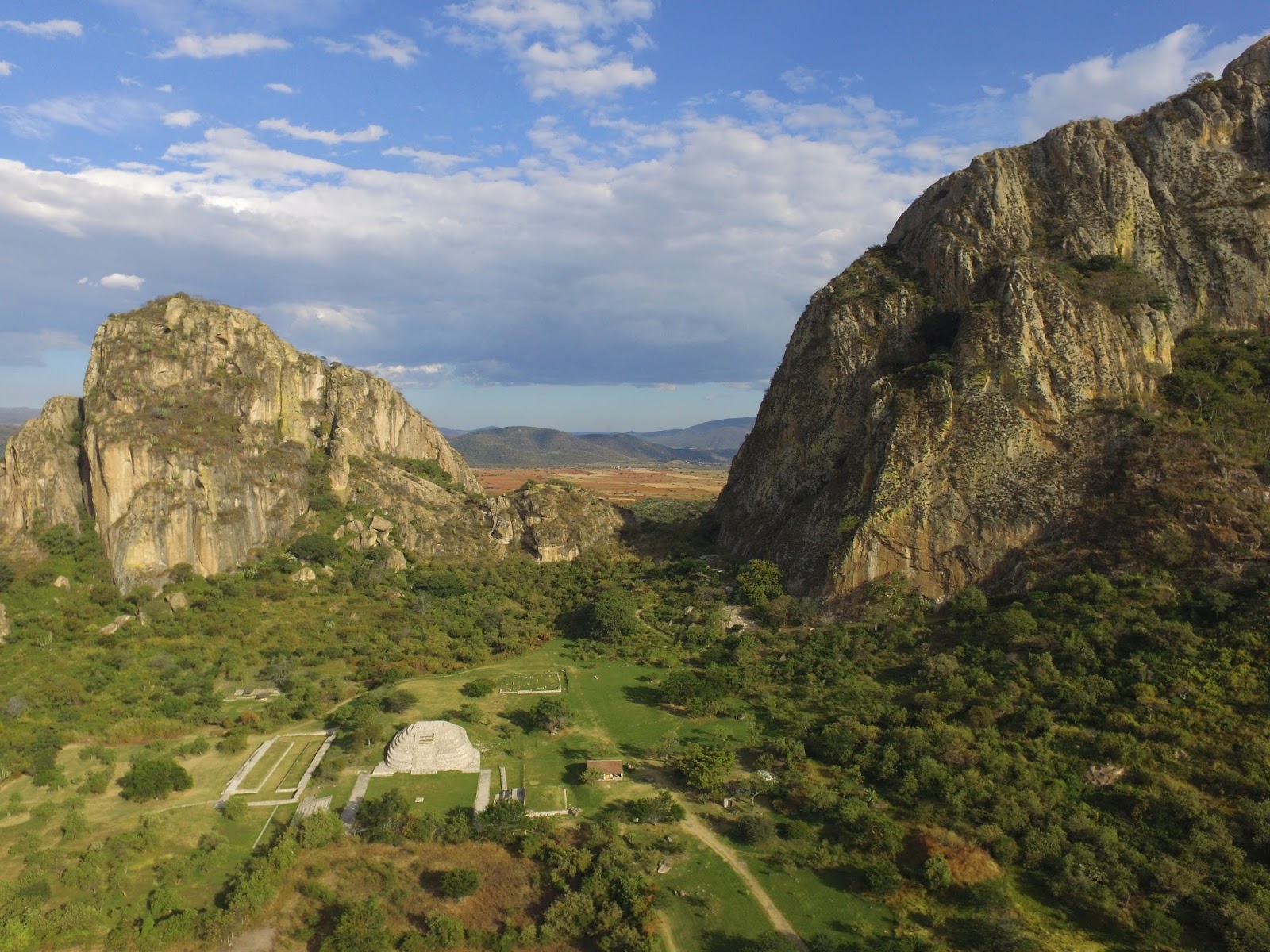
The ancient site of Chalcatzingo from the air - perched between the two hills of Cerro Chalcatzingo (to the left) and Cerro Delgado (to the right) [Photo by Author]
      Esoteric traditions dating back at least to the ancient Greeks and Romans talk about the existence of vast repositories of knowledge dating back to antediluvian times. In more recent times, American mystic Edgar Cayce (also called “the sleeping prophet” for his readings dictated while in a state of trance) became famous for his “Atlantean” readings describing the existence of at least three different “Halls of Records” in different parts of the world. Of these, one was located in Egypt, in the vicinity of the Great Pyramid of Giza; another was located on the island of Atlantis itself and a third in Central America or Yucatan.

The search for the Mesoamerican hall of records has led enthusiasts and independent researchers far into the forests of Yucatan and Guatemala. The remote site of Piedras Negras, in present day Guatemala, is often considered to be the most likely location of the elusive Atlantean records, and has also been the subject of a recent DVD documentary trying to demonstrate the existence of buried structures and an ancient cave system at the site.  

Arrival of the Gods

     Ancient Mesoamerican traditions do indeed describe the arrival of bearded, white-skinned “Gods” from across the Ocean, the most famous being perhaps Quetzalcoatl. Just as in the Atlantean tradition, these “Gods” were responsible for bringing the gifts of civilization to the savage and yet uncivilized people of Mesoamerica. They were the inventor of writing and the calendar, of monumental stone architecture and of all the arts and sciences. Finally, they left, leaving behind a few of their race who would later become the first divine kings of the Mayas and the Toltecs. Upon leaving, the gods carried with them their sacred writings and their most prized relics. According to another legend, they buried great treasures beneath the earth, in caves and other secret places – so that they would one day recover them upon their return.  

The earliest known depiction of the feathered serpent in Mesoamerican Art, dating from 1,200-800 BC - from Monument 19 of La Venta (National Museum of Anthropology, Mexico City) [Photo by Author]
The earliest depiction of Quetzalcoatl, the “feathered serpent” is found among the Olmecs. The famous Monument 19 of La Venta – now in the National Museum of Anthropology in Mexico City – depicts a man with a helmet, sitting within the coils of a serpent and carrying what appears to be a “handbag”, curiously identical to artistic representations of “handbags” carried by gods in Mesopotamian art. Monument 19 dates to between 1,200 and 800 BC, and is therefore one of the oldest monumental expressions of Mesoamerican stone sculpture.  

The Olmecs were the first major civilization in what is today Mexico and Guatemala, flourishing during a period called by archaeologists the Formative Period of Mesoamerica, dating from 1,500 BC to 400 BC. The Olmec heartland was located in the tropical lowlands of the present-day states of Veracruz and Tabasco, along the coast of the Gulf of Mexico. 
The Olmecs have left few, enigmatic monuments, the most famous being perhaps the colossal stone heads unearthed during the 19th and 20th century, together with some of the finest examples of stone sculpture in the entire American continent.

Chalcatzingo

     Chalcatzingo represents an anomaly in Mesoamerican archaeology. For its location in the Central highlands of Mexico, several hundred miles from the Olmec heartland, it contains the most impressive set of Olmec monumental sculpture and rock art anywhere outside of the Olmec capital at La Venta. It becomes immediately clear that the exceptional importance of Chalcatzingo must have been predominantly of a ritual or religious nature. The relatively small dimension of the formative period settlement, hosting an estimate of between five hundred and a thousand people, contrasts with the richness of the decorative art at the site and the large number of sculptured stone monuments.
Another view of Chalcatzingo from the air - The Cerro Delgado in the foreground and the almost perfect pyramid-shape of the Cerro del Chumil in the foreground. The main ceremonial center includes a large plaza surrounded by pyramids and platforms, a ballcourt and a sunken patio. [Photo by Author]
A closer view of the main ceremonial area from the air, against the backdrop of the Cerro Delgado [Photo by Author]
The ancient settlement is nestled in a plain at the base of two high hills, the Cerro Chalcatzingo and the Cerro Delgado. The largest groups of bas-reliefs is found on the cliff face and on some large fallen stone boulders at the base of the Cerro Chalcatzingo, with several others occurring on isolated stone slabs and stelae within the ceremonial center proper.

The most famous rock-cut monument at Chalcatzingo, Monument no.1, is also known, as “El Rey” – ‘The King´. It is found on a high rocky outcrop, less than a quarter of the distance from the base of the Cerro Chalcatzingo. The bas-relief depicts a crowned human-like figure, dressed ornately and sitting on a throne. Most interestingly, the figure is placed inside a cave, from which issue forth strange volutes of what might be wind or mist. The cave is shown in profile, and has the aspect of an open mouth surmounted by an eye. Large clouds are pictured above the cave, with exclamation-like (!) objects falling from them, together with what might be interpreted as symbols for lightning or thunder. The seated figure inside the cave carries a bundle of what appear to be scrolls.

Monument No.1 of Chalcatzingo, depicting the "God of the Mountain" sitting inside a cave in profile, from which a wind appears to blow. The seated figure is carrying a bundle of what appear to be scrolls. Note also the eye above the mouth of the cave, which makes it resemble the open jaws of the Earth monster. [Photo by Author]
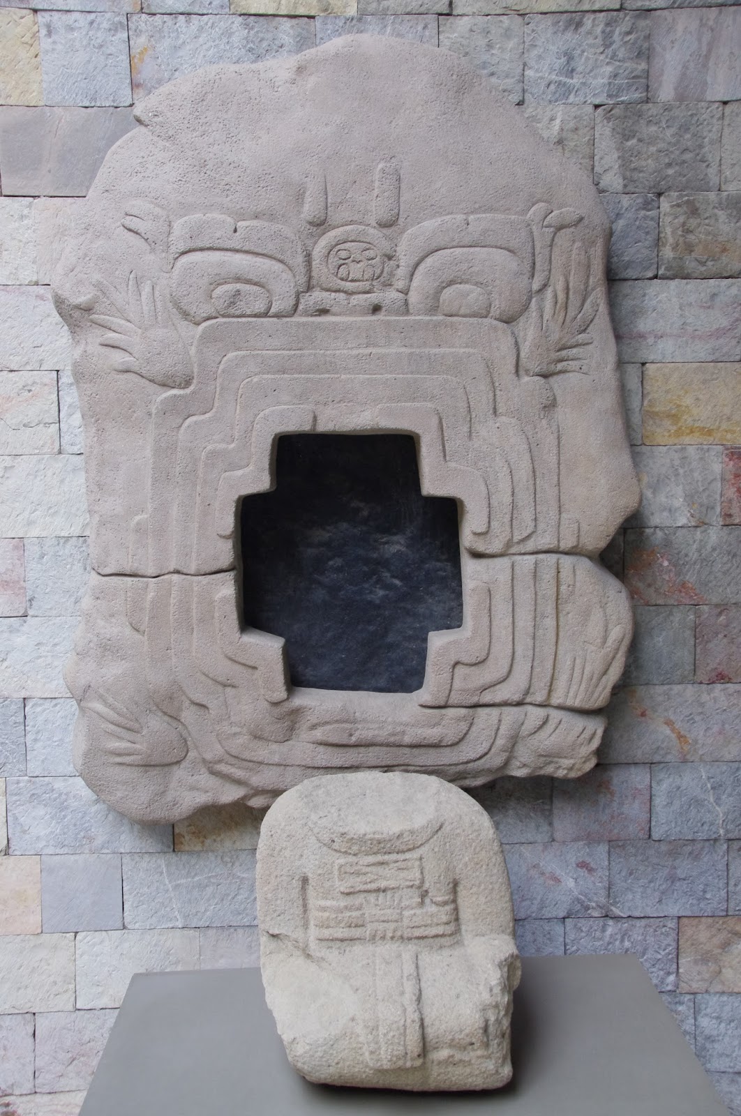
The same cave is represented on Monument no.9, this time from a frontal point of view. The cave has a quatrefoil opening, with a large hole in the middle corresponding to the cave entrance, above which are two eyes similar to the iconography of Monument no.1.
The same cave depicted on Monument No.1, now portrayed from a frontal point of view. Note the curious and artificial-looking quatrefoil opening in the middle, corresponding to the open mouth of the Earth monster (Cast in the National Museum of Anthropology, Mexico City) [Photo by Author]
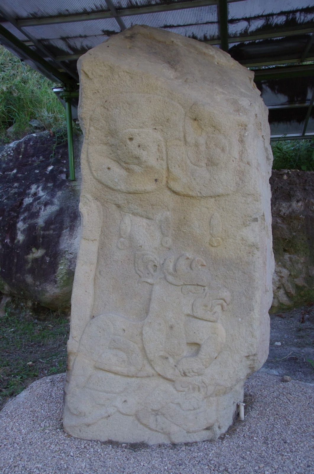
The figure of a Gryphon attacking a man on a loose stela found near the base of the Cerro Chalcatzingo. Note the exclamation signs (!) above the figure, probably representing large drops of rain. [Photo by Author] 
Another fragmentary monument (Monument no. 13) at the base of the hill shows, in the remaining portion, the same cave entrance with a figure, probably a priest, sitting inside it.  

Two more monuments among the over 40 present on the site are interesting for the purpose of our research. One, labelled Monument no. 21 depicts a woman in profile, standing next to a large rectangular object of unknown significance. The object appears to be a large pillar or obelisk, wrapped and covered in intricate designs. The object stands on a kind of platform, to which it seems to be attached. The platform encloses a square space with a diamond shape in the center and an opening in the middle. A similar scene is also portrayed on Monument no.32, this time representing a man mirroring the same gestures of the woman on Monument no. 21.

The monument marked no. 2, show a procession of elaborately clad personages wearing Olmec-style masks. Three figures are standing, brandishing what could be maces or torches, while a fourth figure is laying on the ground. This last figure is the most interesting, for it appears to be bearded and carries an elaborate headdress. It is unclear whether this is the depiction of a deceased or a bound prisoner.

A number of other carvings show serpents, jaguars attacking men (curiously depicted with a beak, which gives them the appearance of Gryphons, a subject otherwise unknown in Mesoamerican art), and an equally curious representation of a man wearing a helmet, who is either swimming or flying – attributes for which it has been aptly named “El Volador”.
The main pyramid-platform in the ceremonial center of Chalcatzingo, with the Cerro Delgado in the background. At its apex, the site had a population of between 500 and a thousand individuals [Photo by Author]
The spectacular landscape of Chalcatzingo, characterized by the remarkable alignment of three mountains, the Cerro Chalcatzingo (in the foreground, left), the Cerro Delgado and the almost perfectly pyramid-shaped Cerro del Chumil (in the background). The volcano Popocatepetl is hidden by clouds. [Photo by Author]

The siting of some of the bas-reliefs on large boulders apparently fallen from the cliff-face of the Cerro Chalcatzingo in the background [Photo by Author]

More of the curious rock carvings found on boulders around the base of the Cerro Chalcatzingo, believed to depict cosmogonical scenes related to the Creation of Man. [Photo by Author]
A secret cavern?

     For the extreme importance attributed to sacred caves in Chalcatzingo art, not a single significant cave is known in the Cerro Chalcatzingo or the neighboring Cerro Delgado. Both mountains represent singular geologic anomalies in an otherwise predominantly flat landscape. Their composition is a reddish porphyry, extremely hard and compact. Seen from a distance, together with the nearby Cerro del Chumil, they have the aspect of massive natural pyramids rising almost unnaturally from the plains of Morelos.

Because of the type of rock of which the Cerro Chalcatzingo and the nearby Cerro Delgado are composed, the presence of natural caves in their interior is extremely unlikely. It is, however, the peculiar way the cave entrance is depicted on the Chalcatzingo monuments and rock carvings that suggests we may not here be dealing with a natural cavern, but rather with an artificial tunnel or vault. The regular, quatrefoil shape of the cavern mouth, together with the other depictions of what appears to be a square or rectangular enclosure, are suggestive of an artificial space rather than a natural one.    
The impressive view from the summit of the Cerro Chalcatzingo, looking towards the Cerro Delgado (below) and the almost perfect pyramid shape of the Cerro del Chumil in the distance. Rising almost unnaturally from the level plain, these isolated peaks, which are moreover found in a perfect alignment to each other, represented places of natural sanctity for the early inhabitants of the Central Mexican highlands and might have inspired some of their earliest creation stories. [Photo by Author]
The figure of “El Rey” depicted on Monument no.1 sitting inside the cavern, further hints to the possibility that documents of some sort, together with “scrolls” and other sacred relics might have been buried inside the cavern. Additionally, the cave might have contained the burial of a very high-ranking individual of the Olmec or pre-Olmec elite.  

Another interesting parallel can be drawn between the carvings representing men being attacked and killed by jaguars, the references to rain in the form of clouds with rain drops and lightning, and the Mesoamerican creation myths. According to these early creation accounts, humanity had suffered at least four previous destructions, in which people were devoured by jaguars or drowned in a deluge. All of this seems to find a parallel in the strange rock-carvings of Chalcatzingo, which, according to several interpretations, might have been intended as an account of creation.

It is certainly suggestive to imagine the cave, surmounted by ominous clouds, as a sort of antediluvian shelter where documents and other artifacts were preserved from the coming deluge by a previous human race.
The strange, almost ´technological´ aspect of some of the objects displayed on the bas-reliefs, particularly the two bound pillars or obelisks portrayed on Monument no. 21 and on Monument no. 32, also seem to be related to the content of the cavern, particularly if the square enclosure depicted at the base of both monuments and is to be interpreted as a stylized cave or Earth monster.
Artist rendition of Monument No.1 of Chalcatzingo, known as "El Rey". One can appreciate both the cave (seen in profile) and the clouds pouring rain from above. 
The carvings on Monument No. 2, depicting a procession of masked men carrying maces or torches and a bearded individual lying on the ground.
Monument No. 21 of Chalcatzingo, depicting a woman touching a rectangular object of unknown significance, which could represent a bound pillar or stela, standing on top of a rectangular enclosure with an opening leading to a diamond-shape in the middle. 
Where, then, was this cavern located?
There are three possible locations for the cave entrance, two on the Cerro Chalcatzingo itself, and one on the nearby Cerro Delgado.  

The most obvious location would be on one side of the bas-relief known as “El Rey” or Monument no.1. There seem to be several large boulders on this spot covering what might be the entrance to a cavern, including parts of the bas-relief itself. The ground there is very humid, which might suggest the presence of a natural water source. There is moreover evidence of fairly recent excavations on the opposite side of the trench in which the bas-reliefs are located. If a cave existed at this spot, it has either collapsed or was covered by debris fallen from the cliff face in ancient times.   
The position of Monument No.1, known as "El Rey" (to the left of the picture), next to what could be the entrance of a collapsed cavern filled with large boulders. [Photo by Author]
A second location could be high up on the Cerro Chalcatzingo, where a rock ledge exists in the cliff face about one quarter of the distance to the summit. The position of this ledge on the almost vertical cliff-face and at an height of over 200 meters over the valley floor makes any exploration attempt almost impossible. The best piece of evidence for the existence of a cave or a yet undiscovered group of bas-reliefs on this spot is the fact that almost all of the rock carvings at the base of the Cerro Chalcatzingo are found on enormous rock boulders that must have detached from the mountain itself. Because of their position, it is very well possible that some of the bas-reliefs originally formed part of a continuous frieze located near the summit of the mountain, whose collapse left only the rock ledge which is still visible exposed.  
A view of the Cerro Delgado from the sunken patio in the main ceremonial area of Chalcatzingo. The profile of a monstruous face with two open eyes, nose and mouth can be made out on the rocks near the summit. [Photo by Author] 
A final possibility is that the cave entrance could be located not on the Cerro Chalcatzingo, but on the nearby Cerro Delgado. Pictures of the cliff face taken with the aid of a drone, do indeed reveal what might be cave openings very near the summit, in a location of almost impossible access. What is most intriguing about these possible cave openings is that they are strongly reminiscent, under certain light conditions, of the eyes and mouth of a giant monstrous face. This might explain the eyes placed around the mouth of the cave on the Chalcatzingo bas-reliefs. 
Could this be the reason why the site was also chosen by the Olmecs for realizing one of their most impressive settlements and artistic displays, so far from their cultural heartland on the Gulf Coast of Mexico? More research will be needed to confirm the existence of a cave entrance on the precise spot corresponding to the “mouth” of the Earth monster carved on the face of the Cerro Delgado.
A closer view of the Cerro Delgado from the air, near sunset. The oblique sunlight makes visible the entrance of some shallow caves near the summit of the mountain that curiously resemble the eyes depicted above the cave entrance on the two most famous Chalcatzingo monuments. If this interpretation is correct, the cave entrance may be found on the rock ledger where the "mouth" of the Earth monster is supposed to be. [Photo by Author] 
The discovery of this cavern might perhaps reveal more of the mysterious origins of the Olmec people and of Mesoamerican civilization as a legacy of the “Gods”.

A drone fly-over of the ancient site of Chalcatzingo and the nearby Cerro Delgado [Video by Author]: 

References:

[1] Chalcatzingo Archaeological Site – From Wikipedia:  https://en.wikipedia.org/wiki/Chalcatzingo
[2] David C. Grove, Ancient Chalcatzingo, University of Texas Press, Austin, 1987 – Online resource: http://www.famsi.org/research/grove/chalcatzingo/index.html
[3] Museum entry on Chalcatzingo, Morelos – National Museum of Anthropology,  Mexico City: http://www.mna.inah.gob.mx/coleccion/huellas-mna/anteriores/chalcatzingo-morelos.html