Showing posts with label huehuepiaxtla. Show all posts

Friday, August 9, 2019

The Lost City of the Eagle


A mysterious Olmec presence in the Mixteca

     Huehuepiaxtla is a small town located in the heart of the Mixteca region, 150 kilometers (100 miles) south of Puebla. Overlooking the town is a huge isolated peak, called by locals ‘La Peña’ – The rock. Tradition has it that the mountain was home to the first inhabitants of the region, who were later turned into stone by the gods.
The municipal president of Huehuepiaxtla, Dr. Florencio Dominguez (left) and our guide German (right) near a section of megalithic stone wall decorated with the image of an eagle on the summit of the Great Rock of Huehuepiaxtla [Photo by Author]
I first became interested in this mysterious site after coming across pictures online of what appeared to be several broken stelas and bas-reliefs [1]. There were also rumors of more extensive ruins near one of the peaks, including great stone walls and a broken obelisk. After contacting the local authorities, the municipal president Dr. Florencio Domínguez was kind enough to arrange for a guide and equipment to climb the peak and document whatever ruins we might find on top.

Upon arriving in Huehuepiaxtla, the summit of the Peña was still entirely shrouded in the morning mist. After the necessary preparations, we approached the cliff from the West. The peak now loomed directly a full 450 meters (1,470 ft) above us and the Rio Mixteco running below. Luckily, no rain had fallen in the past few days, so the rock was quite dry. Florencio explained that had it rained the night or the day before, the rock would have been too slippery to climb. Our guide, German, was an expert climber and one of very few people in town who know the difficult trail to the top.
The Great Rock of Huehuepiaxtla, as seen from the Mixtec River running below and around it. [Photo by Author]
Already at 10:00 am the temperature was nearly 30°C. Near the base of the cliff, we walked through a large flat area, trapezoidal in shape, which appeared to have been artificially leveled with steep embankments on all sides. Some overgrown mounds on the western side suggested this might have been a ceremonial plaza flanked by pyramids.

From there, a small trail led directly to the base of the cliff. Some steps and ledges had been originally carved in the rock, but these were now very worn. The path required to go through some very steep sections of exposed bedrock, which made the climb particularly difficult even in dry weather.
The steep trail leading up to the summit of the Rock of Huehuepiaxtla. [Photo by Author]
Another section of the difficult trail along the exposed cliff face, overlooking the village of Huehuepiaxtla and the Mixtec River below. [Photo by Author]
Along the trail we observed several pieces of obsidian and fragments of pottery. About half-way up, we passed through a set of terraces with massive stone retaining walls. The quality of the visible stonework varied, with some sections composed of huge, finely fitted rectangular stone blocks and others formed of rough boulders. The stone appeared to be a kind of basalt, which was probably sourced locally from the slopes of the great rock itself. 
Dr. Florencio holding a piece of obsidian, probably a small arrowhead, found along the trail to the summit. Note: No artifact was removed during the exploration, and all pieces were returned to their original location. [Photo by Author]
The handle of a broken ceramic vessel. Note: No artifact was removed during the exploration, and all pieces were returned to their original location. [Photo by Author] 
A partially exposed section of a megalithic stone wall about half-way towards the summit of the Great Rock. Some of the larger stones in the picture measure up to 3 meters (10 ft) long. The style of construction is reminiscent of Chimalacatlan and Huaxtla, two early Pre-Classic sites in the state of Morelos.[Photo by Author]
A retaining wall formed of large roughly shaped boulders laid without cement. [Photo by Author]
Some large broken sections of megalithic stone walls, like the one in the picture, suggest the existence of buried monumental structures on this side of the hill. [Photo by Author]
After some more climbing, we finally reached the summit at about noon. The summit consists in fact of a small, mostly level plateau or ridge in between two separate peaks, one to the East and the other to the West. This plateau contained extensive remains of ancient constructions and some overgrown mounds. However, the thick vegetation made it impossible to make out but the general outline of most of the structures.
The small cross located on one of the peaks of the Great Rock of Huehuepiaxtla, overlooking the town and the river below. [Photo by Author]
A rock ledge overlooking the Mixtec River 450 meters below. Note how the rock appears to have been artificially leveled and cut into steps. Several glyphs and rock carvings can be found in this area. [Photo by Author]
Opening our way with machetes through the thick undergrowth we reached the first of the two peaks, where a small cross has been erected that is visible from the town below. From there, it was possible to descend towards a rock ledge directly overlooking the river 450 meters (1,470 ft) below. The ledge appeared to have been artificially leveled and carved into steps or terraces, each just a few meters wide. Various glyphs and symbols were apparently carved on the rock, suggesting that this was in fact a very important point in the sacred geography of the area. Among the glyphs that we could make out were two apparent calendar symbols including the numeral ‘9’ and the figure of an eagle or vulture. The uppermost terrace, where the eagle bas-relief could be seen, was once delimited by a massive megalithic stone wall that emerged directly from the natural bedrock. The joints between the stones looked extremely tight, except for a point where some tree roots had partially dislodged a large vertical block. According to our guide, the peculiar arrangement of the stones around the eagle glyph indicated a hidden passageway. What made the existence of a passage through the rocks very likely was the presence of another bas-relief, depicting a crouching jaguar, which appeared to continue beyond the joint into the wall. From this point, it was also possible to see the entrance of another cave near the base of the cliff. Local traditions speak of vast subterraneans under the Peña. One of these is said to be covered in carvings and mysterious figures, but no entrance to these subterraneans is presently known.
A mysterious glyph on one of the rocks near the eagle carving. [Photo by Author]
A section of what appears to be a megalithic stone wall with the carving of an eagle and a calendar glyph with the numeral '9'. Note the peculiar arrangement of the stones to the right of the carving, allegedly concealing the entrance to a subterranean. [Photo by Author]
A close-up view of the eagle glyph on the same rock face. The figure of a jaguar can be faintly made out to the right of it. [Photo by Author]
Another glyph near the edge of the rock overlooking the Mixtec River some 450 meters below. The glyph is inscribed inside a circle and is also accompanied by the numeral '9', represented by a bar with four dots. [Photo by Author]
From this rock ledge, we continued along a trail overlooking the precipice in the direction of a small plateau separating the two peaks. There, in a small plaza facing an ancient overgrown pyramid lay one of the most fascinating monuments of antiquity in this parts of Mexico. It was a huge fallen stela, some 3 meters (10 ft) long, carved on one side with the image of an undefinable creature. It had slightly open legs, from which emerged what appeared to be a tail. Hands and feet looked like claws, but the creature appeared otherwise humanoid. The head could be that of a bat, with large pointed ears. The presence of clearly marked breasts suggested that the subject represented was a female. It was a unique type of stela, for the deeply embossed relief and the frontal depiction of the main figure. The stela was probably part of a pair that had been once erected in front of the main pyramid. Another fragmentary stela, now in the main square of Axutla, is also said to have been found at Huehuepiaxtla, and shows a very similar iconography. In this latter case, however, the figure depicted looks clearly human, possibly a dancer. The stela of Axutla is also significantly smaller, and the carving much shallower and less precise.
A large fallen stela in front of the main pyramid on the summit of the Great Rock of Huehuepiaxtla. The figure depicted is vaguely anthropomorphic, with claws in the place of hands and a curious head with pointed ears resembling a bat. [Photo by Author]
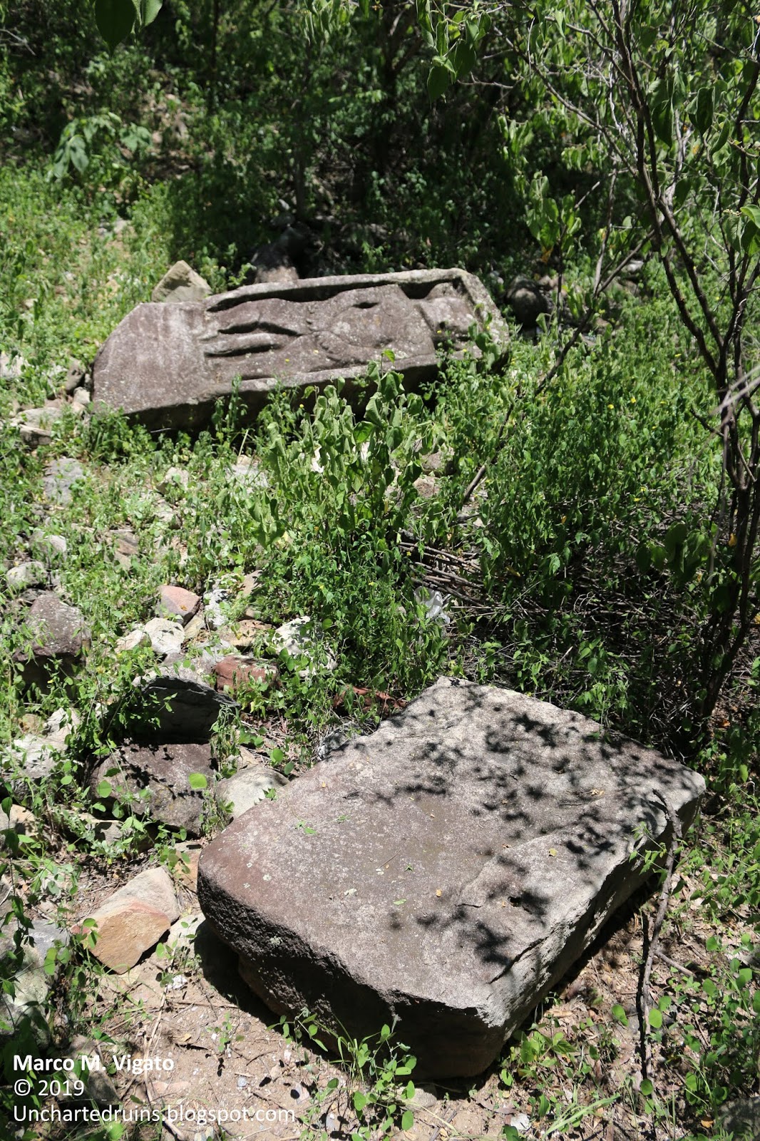
Another view of the same fallen stela with a smaller stone block that may have been its base or an offering table, also near the base of the main pyramid. [Photo by Author]
A view of what appears to be the main pyramid of the site, with its partially exposed stone core. [Photo by Author]
After passing the main pyramid, the trail led in the direction of the second peak. About half-way up towards the summit, we found a pair of strange megalithic arrangements. The first apparently consisted of some huge boulders, each probably weighting 1 ton or more, roughly piled up to form some sort of cairn about 3 meters (10 ft) high. A short distance from this first arrangement was a second one, consisting of even larger basalt columns stacked together as to form a fence. I found the resemblance to the famous Olmec megalithic tomb of La Venta particularly striking, especially for the use of prismatic basalt columns. From there, we entered another small plaza delimited on three sides by a stone wall. The wall had entirely collapsed, but the debris still reached up to 1 meter (3 ft) in height. The purpose of the wall was probably to delimit a sacred precinct in front of another very ruined pyramid that occupied the summit of the second peak. A large hole could be seen where a temple would have stood on top of the pyramid, probably dug by looters in search of treasure. From this vantage point it was possible to see at a distance of some 5 kilometers another giant rock, known as the Peña de Tlaxcuapan, where more ancient ruins are said to exist. 
A cairn formed of huge megalithic stone boulders on the summit of the Great Rock of Huehuepiaxtla. It is possible that these stones once formed part of some large fallen structure. [Photo by Author]
A curious megalithic arrangement consisting of several basalt columns, each up to 3 meters (10 ft) high. This is reminiscent of the famous Olmec tomb of La Venta, probably early Pre-Classic. [Photo by Author]
A view of the Rock of Tlaxcuapan from the summit of small pyramid that occupies the second peak of the Great Rock of Huehuepiaxtla. [Photo by Author]
We then began a difficult descent along a small overgrown pathway towards a spot where our guide German claimed a huge broken stela or obelisk could be found. After a turn, we found ourselves in front of an immense stone wall, formed of huge megalithic blocks up to 4 meters (13 ft) long, laid in regular courses without mortar or cement. The wall apparently formed the side of a large stone platform or terrace, on top of which rose a second platform also lined with great megalithic stones. The overall impression was one of extraordinary antiquity. Near the base of the lower platform we found another curious arrangement of basalt columns, each probably 3 or 4 meters  (10-13 ft) long, placed horizontally as to form a kind of bridge. We could not determine whether the columns actually formed part of the roof of some buried structure, but this seemed very likely. A short distance from there we reached the ‘Stone of Sacrifice’. This was in fact an enormous broken stela, which may have stood up to 6 meters (20 ft) tall when still erect, but which now lay broken in four parts. The decoration on the stela betrayed a clear Olmec influence. Although now badly defaced, it probably depicted a ruler crowned by what appeared to be a very elaborate headdress.
A set of huge monolithic basalt columns laid horizontally as to form a sort of bridge, possibly the roof of a tomb. [Photo by Author]
A section of a massive megalithic wall forming the side of a terrace. Some of the stones pictured above measure over 3 meters (10 ft) long, with a weight of several tons. [Photo by Author]
Another view of the same megalithic terrace, formed of massive prismatic basalt columns laid in rows without mortar or cement. Probably early Pre-Classic. [Photo by Author]
More ruined megalithic stone walls, partially covered by vegetation. [Photo by Author]
A view of some other megalithic structures on the upper terrace, also built of huge blocks of prismatic basalt laid without mortar or cement. [Photo by Author]
The great broken stela known as the 'Stone of Sacrifice' at the base of the lower terrace. The fragment on the left shows a badly eroded head and torso, while the larger fragment on the right contains part of an elaborate headdress. The style of the sculpture is typically Olmec. When erect, the stela (now broken in at least four pieces) would have stood at least 6 meters (21 ft) tall. [Photo by Author]
More Olmec-style carvings could be found near the base of the Peña. These appeared to have also been part of another large broken stela. A glyph accompanied by the numeral ‘4’ could be seen on one of the fragments.
Fragments of a large broken stela found near the base of the Rock of Huehuepiaxtla. A glyph with the numeral '4' can be clearly made out in the center of the picture. [Photo by Author]
More fragments of the same broken stela, with apparently Olmec carvings. [Photo by Author]
The rock of Huehuepiaxtla was certainly a very important site in ancient times, and it is a pity that so little is known about it. Everything suggests that this was a major ceremonial center in the Pre-Classic period, probably as early as 1,000 B.C., and may be related to the other Olmec sites in the region, at Chalcatzingo, Chimalacatlan, Huaxtla, Teopantecuanitlán and Juxtlahuaca.

The possibility of a connection between these sites is further suggested by the fact that a line drawn through Chimalacatlán and Huaxtla (as described in a previous article [2]) leads directly to the rock of Huehuepiaxtla. A continuation of the same line crosses the nearby rock of Tlaxcuapan and ends at Apoala. This alignment of five sites, all displaying unusual megalithic architecture, appears to be hardly coincidental.
It is only to be hoped that the Mexican Institute of History and Anthropology (INAH) also gathers an interest in this now forgotten site and helps preserve it from looting for the benefit of future generations.  
A herd bathing in the Mixtec River, at the base of the Great Rock of Huehuepiaxtla. [Photo by Author]
Another view of the Rock of Huehuepiaxtla, standing in monumental isolation in the hilly landscape of the Mixteca. [Photo by Author]
Part of a broken stela, allegedly from Huehuepiaxtla, found in the main square of the town of Axutla. [Photo by Author]
Another stone fragment in the main square of Axutla, possibly from the same stela. [Photo by Author]
References

Unfortunately, no bibliography could be found concerning Huehuepiaxtla and its ruins, as the site is presently unpublished and no mention of it exists in academic literature. 

[1] La Gran Peña, origen de mitos y leyendas en la Mixteca poblana y oaxaqueña, in MunicipiosPuebla.mx, December 22, 2013 – On-line resource: http://municipiospuebla.mx/nota/2013-12-22/acatl%C3%A1n-de-osorio/la-gran-pe%C3%B1a-origen-de-mitos-y-leyendas-en-la-mixteca-poblana-y

[2] Marco M. Vigato, Tamoanchan, in Search of the Lost Cradle of Mesoamerican Civilizations, in Ancient Origins, February 9, 2019 – On-line resource:https://www.ancient-origins.net/ancient-places-americas/tamoanchan-0011452

Also on this blog: The Location of the Mesoamerican ‘Hall of Records’ at Chalcatzingo: http://unchartedruins.blogspot.com/2016/11/the-location-of-mesoamerican-hall-of.html - Note the striking similarity between the profile of the rock of Chalcatzingo and the Peña of Huehuepiaxtla, as if to suggest that these may have in fact been sister sites belonging to the same culture

Monday, October 2, 2017

Join us on our next Expeditions

An Update on Upcoming Expeditions

The objective of this post is to share more details on some of our upcoming expeditions that may help unravel the mystery of the origins of the great and still largely unknown megalithic civilization of the Central Mexican highlands. Many of these locations are of difficult access, in remote or impervious terrain. We need motivated people to help us conduct these expeditions on the ground and document these ancient sites (with photos, videos and aerial images) – many of which have not been published before.  

Anyone interested should contact me in private at the address: unchartedruinsblog@gmail.com

Here is an initial list of sites for investigation, with some preliminary information on their significance to our quest for the lost megalithic civilization.    

1) Exploration of the Sierra de Huautla, Morelos

The construction of the walls of Chimalacatlan in an old postcard drawing [Courtesy: Mexicoenfotos.com]
We believe that the center of the megalithic civilization of ancient Mexico must be located somewhere in the still unexplored reaches of the Sierra de Huautla, a mountainous and heavily forested area to the South of the State of Morelos. This is where ancient legends located Tamoanchan, the fabulous “place of origin” of all Mesoamerican civilization – a city founded by the Gods themselves. 

In February of 2015 we explored the mysterious ruins of Chimalacatlan in the Sierra de Huautla (Link here). This is a unique megalithic site consisting of immense stone walls and platforms occupying the summit of a hill. For its cyclopean style of construction, Chimalacatlan has been compared to some of the finest megalithic constructions of Peru, and is of a type entirely unknown in Mesoamerica. The age of these ruins is unknown, but early investigators of the site conservatively situated their origin in the 1st or 2nd millennium B.C. More reports have since surfaced on the existence of more extensive structures in the mountains near the modern day town of Huaxtla. These structures have been described as clearly megalithic or cyclopean, consisting of large stone blocks measuring as much as 2 meters in length. Several pyramids, plazas and large stone walls have been reported on the site, compatible with the presence of a large city.  

The goal of the expedition will be to document and map these ruins, collect evidence for the existence of additional unexplored sites in the Sierra de Huautla and investigate their architectural analogies with other megalithic/ cyclopean structures in Mexico, Peru and elsewhere.    

Additional information from the Mexican National Institute of History and Anthropology (INAH) - Link here

2) The Lost Pyramid of Teopantepec and the “City of the Gods” on the Cerro Colorado

An illustration of the pyramid of Teopantepec, as it stood in 1807 [Dupaix, Antiquités Mexicaines, p.4, Plate 3]
In a previous article (Link here), we identified the Cerro Colorado overlooking the modern day town of Tehuacan, Puebla, as the most likely location of an ancient pyramid known from early 18th and 19th Century documents as Teopantepec (“House of God on the Mountain”). It is possible that the original structure collapsed some time after these early reports were composed, but some remains of its megalithic stone facing may still be found on the Cerro Colorado. Local traditions mention a “City of the Gods” or a “Ciudad Perdida (Lost City)” on the nearly inaccessible summit of the mountain. On the site of this supposed lost city, satellite pictures show a vast rectangular enclosure with what appear to be the remains of an ancient pyramid in the middle. 

The expedition will start from the nearby archaeological site of Tehuacan Viejo, from which a trail leads to the summit of the Cerro Colorado. It can probably be completed as a day-trip from Puebla.   

3) Acatzingo de la Piedra – A monolithic pyramid and cyclopean walls 

A short distance from the town of Malinalco (subject of another article – here), lies the town of Tenancingo and the site of Acatzingo de la Piedra. A monolithic stone pyramid has been recently found on the mountain known locally as the “Cerro de la Malinche”. The pyramid is known as the “Cama de Moctezuma”, and a number of pictures and videos of it exist over the internet. Other pictures show what appear to be portions of megalithic/ cyclopean walls partly covered by forest. 

We will use a drone to map any structures that might exist closer to the summit of the hill, as well as any visible megalithic remains. This expedition can also be completed as a day-trip from Malinalco or Mexico City.   

Additional information from the Mexican National Institute of History and Anthropology (INAH) - Link here

4) Mexico’s Marcahuasi – The Sacred Valley of Tepoztlán

A satellite view of the Valley of Tepoztlan, with the Popocatepetl volcano in the background [Courtesy Google Earth]
Unbeknown to many, the famous Peruvian explorer Daniel Ruzo, who first documented and publicized the mysterious rock sculptures on the plateau of Marcahuasi, spent the last years of his life in Mexico in what he called the “Sacred Valley of Tepoztlán”. There, he believed that rock sculptures even larger and older than those of Marcahuasi existed in the mountains surrounding the town of Tepoztlán. He documented hundreds of colossal rock sculptures, forming what he called a “hidden blueprint” or a map pointing to the location of a legendary “Hall of Records”. Since the publication of his book “El Valle Sagrado de Tepoztlán”, the valley has however failed to attract a similar interest to its Peruvian counterpart. 
   
The town of Tepoztlán, with its stunning landscapes and the enigmatic pyramid of Tepozteco, attracts thousands of tourists every year. Only very few of them, however, are aware of the research of Daniel Ruzo. The goal of our expedition will be to document many of the rock sculptures first described and photographed by Ruzo in his book, identifying signs or marks that could point to their artificial rather than natural origin. Because of the easy accessibility of Tepoztlán from Cuernavaca and Mexico City, this can also be completed through a number of day-trips from Mexico City. We will also use a drone to document the rock sculptures from the air and identify any other features not detectable from the ground. 

5) The Mysterious Rock of Apoala

The great 19th Century ethnologist and explorer Hubert H. Bancroft collected the following tradition of the “Flying Gods” of the Mixteca. After a great deluge, two gods appeared to repopulate the Earth: “They made a very sumptuous palace – a masterpiece of skill – in which they made their abode upon Earth…on the highest part of this building was an axe of copper, the edge being uppermost, and on this axe the heavens rested […] This rock and the palace of the Gods were on a mountain in the neighborhood of the town of Apoala in the province of Mixteca Alta. The rock was called ‘The Place of Heaven´, there the Gods first abode on Earth.”  [Hubert Howe Bancroft, The Native Races, Vol. IV] 

Such a rock does indeed exist in the vicinity of the modern day town of Santiago Apoala. Several deep caves associated with the legend exist in the gorges of Apoala, and a number of very curious petroglyphs and Olmec rock-reliefs (one in particular, known as the “Danzante”) are said to exist near the summit of the rock of Apoala. 

We will be looking for remains of ancient structures on or near the summit of the rock of Apoala, which may offer evidence for the existence of a “Palace of the Gods”. We will also investigate traditions of a labyrinth of ancient tunnels in a cave known locally as the “Cueva del Diablo (The Devil’s lair)”.  

Additional information and pictures can be found here.

6) An ancient obelisk and carved reliefs in Axutla, Puebla

A satellite view of the Rock of Huehuepiaxtla (Axutla, PUE), along the Rio Atoyaque [Courtesy Google Earth]
Also in the region of the Mixteca Alta, the village of Huehuepiaxtla (Axutla, PUE) is home to a colossal rocky outcrop known locally as “La Gran Peña (the great rock)”. A number of pictures have been circulating on the internet of ancient carved reliefs and stelae found in the vicinity of the mountain, containing unusual depictions of supernatural beings which were believed to inhabit its summit. It is also said that ancient structures, including a large “stone obelisk” may exist on the summit – although no documentation of these puzzling remains could be found.  

The expedition can probably be conducted as a day-trip from Puebla, with the objective of documenting many of these curious finds and confirm the existence of ancient megalithic structures near the summit of the Rock of Huehuepiaxtla.  

Additional information and pictures can be found here.

7) A journey into the Underworld of Teotihuacan

A large chamber in one of the caves that form the ancient Underworld of Teotihuacan, located a short distance to the East of the Pyramid of the Sun [Photo by Author]
There are reportedly miles of ancient tunnels and interconnected cave systems under the ancient pyramid-city of Teotihuacan. We confirmed the existence of the tunnels and explored a small portion of this labyrinthine network to the East of the pyramid of the Sun in February of 2017 (Link here). Additional tunnel entrances are reported to exist near the palatial complex of Oztoyahualco, near Acolman, on the Cerro Gordo and in the Sierra de Patlacique to the south of the ancient city (these latter apparently carved in a very hard andesite). 

Some of the tunnels are rumored to extend for many miles. Early archaeological reports speak of labyrinthine tunnels leading to vast hollowed chambers and pillared halls deep under the earth, which may have an association with the legendary Chicomoztoc, the “Place of the seven caves” considered to be the ancestral homeland from which emerged the ancestors of the Aztec tribes. 

This expedition is likely to require proper speleological equipment for the exploration of the underground passages. 

8) The mysterious subterraneans of Xochicalco

A portion of an ancient tunnel under the acropolis of Xochicalco [Photo by Author]
A number of ancient tunnels extend under the acropolis of Xochicalco, and there are also rumors of underground chambers and labyrinthine passageways running for many miles all around. Only a small portion of the tunnel system is presently open to the public (near the so-called solar observatory or “Cueva del Sol”). Other entrances can be found on the flanks of the acropolis, which lead to collapsed portions of the tunnel system (some of which we explored in April of 2017) – the tunnels are apparently very regular and are dug through a hard local kind of limestone. During the same trip we also documented large stretches of what appear to be polygonal/ cyclopean walls forming the substructure of the acropolis. The nearby Cerro de la Bodega is also said to contain a number of tunnel entrances.   

This expedition is also likely to require proper speleological equipment for the exploration of the underground passages. 

Link to a previous article on Xochicalco here

9) The Aztec sanctuary on Mount Tlaloc

A 3D reconstruction of the Aztec sanctuary on Mount Tlaloc and the "Ghost Mountain" optical illusion [Courtesy: masdemx.com]
The chief sanctuary of Tlaloc – the Aztec god of rain, was located on the mountain that bears the same name in the vicinity of Mexico City. The sanctuary on the summit, at an altitude of nearly 4,100 meters above sea level, is considered to be among the highest archaeological ruins in the world, and contains a number of significant astronomical alignments, including a long processional ramp and a ruined pyramid-observatory.

A curious optical phenomenon takes place on the summit of Mount Tlaloc during the month of February. Known as the “ghost mountain” (La Montaña fantasma), the phenomenon consists in an apparent optical mirage of a non-existing mountain in front of the peak of Mount Tlaloc.  

The hike to the summit of Mount Tlaloc does not require any special technical equipment, but one night of camping on the mountain is required.  

Additional information and pictures can be found here

10) The search for the Cross of Xaagá 

In a previous article (Link here), we described a mysterious megalithic tomb somewhere in the vicinity of Mitla. The tomb is in the shape of a cross and consists of several immense megalithic stone blocks measuring as much as 6-7 meters long. Several black and white pictures of the alleged tomb exist, dating from the early 1900’s, but its exact location has apparently been lost. If found, the tomb would be one of the largest megalithic structures in the entire American continent. The area is also characterized by the presence of rock art and cave paintings dating back thousands of years. 

One of the few existing pictures of the large cruciform tomb at Guiaroo, dating to the time of the 1902 excavations. Each one of the immense monolithic stone blocks employed in the construction measured over 6 meters long with an estimated weight of nearly 50 tons. The location of this remarkable megalithic structure has apparently been lost. [Photo Saville, 1902]
Another view of the same structure after partial excavation, taken at an angle. [Photo Saville, 1902]
An expert guide will be required for this trek, which can probably be done on horse or mule as a day trip from Oaxaca.