Showing posts with label Mexico City. Show all posts

Friday, April 5, 2019

Ancient high-technology in the National Museum of Anthropology, Mexico City

The National Museum of Anthropology in downtown Mexico City [Photo by Author]

The National Museum of Anthropology in Mexico City hosts one of the largest collections of archaeological artefacts and pre-Columbian masterpieces in the world. Among those, are a number of pieces, some extremely famous, others entirely neglected by tourists, that exhibit a level of technical sophistication far beyond the capabilities of the ancient peoples who supposedly realized them.

1. The Aztec Calendar stone
The Aztec Calendar stone - This 24-ton monolith was discovered in 1790 in what is today the great Cathedral Square of Mexico City, near the Aztec Templo Mayor [Photo by Author]
This enormous monolith, weighting an estimated 24 tons, was discovered under the ruins of the Templo Mayor, the greatest temple of the Aztec capital city of Tenochtitlan. The enormous stone must have been dragged by thousands of peoples from quarries located at a distance of over 22 kilometers. It contains three rings or calendar wheels surrounding a central disk containing a depiction of the present Sun and of the four previous Eras or Suns, which ended in cataclysms. The first ring contains 20 glyphs corresponding to the days of the 18 months’ Aztec calendar. A second ring is similarly divided into squares, each containing 5 points, while the outermost ring contains the depiction of entwined fire serpents and more calendrical symbols. With its complicated symbolism and concentric rings or gears, the Aztec Calendar stone appears eerily similar to the petrified version of a mechanical device. 
Another bas-relief displaying a circular object (probably a shield) resembling the calendar stone. Was this curious design based on an ancient mechanical device? [Photo by Author]
2. The monolith of Coatlinchán
The giant monolith of Coatlinchan, as it stands on a fountain outside of Mexico City's National Museum of Anthropology [Photo by Author]
The monolith of Coatlinchán is a colossal ancient statue that for centuries lay abandoned in an andesite quarry near the ancient city of Texcoco, before it was finally moved to Mexico City in 1964. The same andesite quarry is also believed to have provided much of the construction materials for the stone sculptures and megalithic architecture of Teotihuacan, some 25 miles to the North-East of Mexico City. It is believed that the monolith of Coatlinchán is a representation of the Rain-god Tlaloc. It is nearly 7 meters high and weighs an estimated 152 tons, making it the largest ancient statue and one of the largest carved monoliths in all the American continent. The monolith now decorates a fountain in front of the National Museum of Anthropology in downtown Mexico City.

3. Colossal Aztec sculptures
An enormous serpent head carved out of a single block of andesite - It is believed to be a depiction of the 'Fire Serpent' and would have once adorned the sacred precinct of the Templo Mayor. [Photo by Author]
The Aztec room of the National Museum of Anthropology contains a number of colossal Aztec sculptures that once adorned the area of the Templo Mayor. Some of the most impressive ones include a giant crouching jaguar, depictions of the fire serpent or Tochancalqui, and some enormous serpent heads. The Coatlique statue is a particularly striking piece of sculpture depicting the ancient Aztec goddess of snakes, wearing a gown of entwined serpents and a necklace of severed human heads and hearts. From her decapitated head, two great serpents spring out. These statues, each weighting many tons, were carved from the hardest basalt and andesite stone by a people that had allegedly no knowledge of metal tools, and may be ranked among the finest and most striking pieces of sculpture anywhere on earth.
The Coatlique statue, also carved from a single block of andesite measuring 2.7 meters (8.9 ft) tall. It was considered so terrifying that soon after its discovery in 1790 it was quickly reburied on fear that it would encourage the return of bloody rituals and necromantic practices. [Photo by Author]
4. Teotihuacan’s ‘Goddess of Water’
This statue of the 'Water Goddess' or 'Great Goddess' of Teotihuacan was found near the base of the Pyramid of the Moon. It was probably part of a pair that decorated a large, monumental temple on top. [Photo by Author]
This enormous statue popularly known as the ‘Goddess of Water’ was found at Teotihuacan, near the base of the Pyramid of the Moon. The huge andesite statue is over 3.2 meters (10 ft) tall and weighs an estimated 15 tons. It is stylistically similar to the great monolith of Coatlinchán and may have originally formed part of a pair of statues decorating a temple on top of the Pyramid of the Moon.
This group of sculptures, which once decorated the Pyramid of the Sun in Teotihuacan, is a fine example of the great mastery achieved by the builders of Teotihuacan in working with hard stones like andesite. [Photo by Author]
5. Colossal Olmec stone heads
A colossal stone head in the Olmec room of Mexico City's National Museum of Anthropology. Notice the negroid features and what appear to be en elaborate helmet covering the head. [Photo by Author]
Over 20 colossal Olmec stone heads are known, most of which from the Mexican states of Veracruz and Tabasco. The two examples that are found in Mexico City’s National Museum of Anthropology come from the ancient Olmec capital of San Lorenzo, Veracruz. Other than for their enormous size (each weighs between 8 and 12 tons), these sculptures are remarkable for their ornate headdresses and negroid features, with slanting, deep-set eyes and high cheek bones, suggesting they may depict individuals of a race different from that of the present inhabitants.
More examples of Olmec sculpture - This life-sized statue of a wrestler is notable for the presence of a beard and the highly naturalistic pose. [Photo by Author]
Monolith n.20 from La Venta, dated to 1,200-800 B.C., contains one of the earliest depictions of the Feathered Serpent and the Myth of Quetzalcoatl. [Photo by Author]
6. Drilled alabaster vases
An exceptionally drilled alabaster vase. Found in the ancient Toltec capital of Tula, Hidalgo, this unfinished vase shows clear evidence of the use of a tubular drill for carving its interior and hollowing out material. [Photo by Author]
Another view of the same vase - Note the perfect elliptical shape and the evidence of drilling in the interior. It is inconceivable that such an object could have been manufactured without the use of the lathe and of sophisticated metal tools and abrasives. [Photo by Author]
A unique example of a drilled alabaster stone vase can be found in the Tula room. Discovered in Tula, Hidalgo, this unfinished vessel was carved with the aid of a tubular drill that left peculiar drill marks on the inside. There is no explanation as to how this was achieved by a people that supposedly ignored the use of metals but the material used (a very fine kind of alabaster) and the general workmanship are reminiscent of the finest early Dynastic Egyptian stone vessels.
Another example of a drilled alabaster vessel from the Olmec culture, with a lizard sculptured on the outside. [Photo by Author]
Another drilled alabaster vessel from the Maya region. Its decoration is strangely reminiscent of the early Chinese bronzes of the Xia and Shang Dynasty. [Photo by Author] 
7. The ‘Monkey Vase’ of Texcoco
The famous 'Monkey Vase' from Texcoco, a masterpiece of ancient obsidian stonework and one of the most valuable artifacts in Mexico City's National Museum of Anthropology. [Photo by Author] 
This small obsidian jar is perhaps one of the most exquisite objects in Mexico City’s National Museum of Anthropology. Made of a single piece of obsidian, it depicts a monkey holding its tail above its head as a kind of handle. It is not known by what means the hard obsidian (a type of black volcanic glass) was finished to achieve a perfect mirror polish without breaking it, nor how it was so precisely carved on the inside with walls just a few millimeters thick. The vessel was discovered in 1880 inside a tomb near the ancient city of Texcoco, but nearly nothing else is known of its provenance. 
Another view of the same vessel, from the front. The quality of the polish and finesse of the carvings is astonishing. [Photo by Author]
Another view of the same 'Monkey Vase' of Texcoco. The perfect geometry of the vase and the quality of its mirror-like polish can be appreciated from every side. [Photo by Author]
8. Incredible obsidian and rock-crystal objects
A set of remarkable obsidian ear spools, believed to be of Azted manufacture. The thickness of the walls is less than 1 mm, making each disc look almost transparent. [Photo by Author]
Similar to the Monkey Vase of Texcoco, but on a smaller scale, these ear spools and pendants are also made of obsidian. They are carved to a perfect mirror-like polish, with walls so thin as to be almost transparent. Other examples are known from rock crystal and other extremely hard stones. It is a mystery how this level of workmanship was achieved without the aid of sophisticated metal tools by a people who allegedly ignored even the use of the lathe. 

9. Polished basalt statues
A polished basalt snake, also believed to be of Aztec manufacture. The stone has been polished to a perfect mirror-like finish. [Photo by Author]
The same level of mirror-like finish that is found on the smallest obsidian and jade objects can also be found on some larger basalt statues, like a number of magnificent coiled serpents. These works of art are not only striking for their extremely accurate workmanship, but also for their precise geometry that is almost suggestive of the use of machines or other unknown mechanical methods for cutting and shaping the stone.
A detail of another coiled snake sculpture, from below. Note the perfect geometry of the scales and the spiral-form of the sculpture, which makes it rank among the finest artworks of all times. [Photo by Author]
10. The Codex Boturini
An illustration from the Codex Boturini, depicting the Aztec's migration from Aztlan to the mythical mountain of Coatepetl. [Photo by Author]
The mystery of the Codex Boturini lies not in how it was made, but rather in its contents. One of only a handful surviving Aztec codices, it contains a detailed account of the Aztec migration from a mythical place called Aztlan, depicted as a large island surrounded by water. From Aztlan, the Aztecs allegedly came to Mesoamerica, passing through a number of mythical and real historical places. The Codex Boturini has often been claimed to preserve the memory of the Aztec’s ancestral migration from Atlantis. The very name of Aztlan may be translated as the ‘place of whiteness’ or the ‘white island’. The equally legendary Chicomoztoc, the ‘Place of the Seven Caves’, from where the ancestors of the Aztecs emerged to repopulate the earth appears instead as a subsequent step in the Aztecs' migration after their departure from Aztlan.

Monday, July 2, 2018

The Secret Tunnels of Ancient Mexico and Central America

Just like Peru, with its countless legends of ancient tunnels and buried treasure, rumors of a vast ancient tunnel network that extends under much of Mexico and Central America are nearly as plentiful, many dating to a time earlier than that of the Spanish conquest. The Aztecs themselves believed that their ancestors had emerged from this mysterious underworld after a great cataclysm. In Aztec myths and legends, this underground world was known as Chicomoztoc, the “place of the seven caverns”. Maya creation stories also speak of the underground kingdom of Xibalba as a real, physical place, from which humanity had emerged at the dawn of time. Caves and ancient tunnels were believed to be the gates to this mysterious subterranean world.
The entrance to the Maya labyrinth of Yaxchilan, in Chiapas, a sprawling underground complex of chambers and corridors that may conceal the entrance to Edgar Cayce's fabulous Hall of Records. [Photo by Author]
What follows is a list of the most famous ancient cave and tunnel entrances found throughout Mexico and Central America. 

Texcoco – The palace of Nezahualcoyotl
The entrance to one of the many ancient tunnels that pierce the hill of Tezcotzingo. [Photo by Author]
The hill of Tezcotzingo, overlooking the ancient city of Texcoco, a short distance from Mexico City, contains the remains of several monolithic temples, rock-cut stairways and artificial aqueducts. It is believed that these remains date to the time of the king Nezahualcoyotl (1402-1472 AD), who built a magnificent palace on the hill. The unusual megalithic character and severe erosion of these structures may however point to an antiquity far more remote than the foundation of the city of Mexico by the Aztecs. Several cave entrances are visible on the hill of Tezcotzingo, all of which are presently blocked. When Bullock visited the ruins of Texcoco with the hill of Tezcotzingo in 1824, he could still admire the ruins of several pyramids and the great palace of the Kings of Texcoco on the hill, “of huge basaltic stones, carved and polished with the utmost exactness”. Bullock also described the whole mountain as “entirely perforated by artificial excavations”, in which immense riches were said to be buried, although for no amount of money his guides would accept to take him into the underground labyrinth. A tunnel entrance dug into one of the flanks of the hill leads through a steep descending passageway to an underground chamber. The entrance to another collapsed tunnel is visible below the floor of the chamber. It is rumored that this tunnel connects with another blocked passage exiting below a large monolithic basin known as the “Bath of the King”. 

A report of our 2016 expedition to Texcoco and Tezcotzingo can be found here.

Mexico City – The “Tomb of the Aztecs” on the hill of Chapultepec
The "Tomb of the Aztec Kings" inside Mexico City's Chapultepec Park. A V-shaped rock covered with mysterious hieroglyphs (to the left of the picture) is believed to conceal the entrance to a legendary tomb, inside a labyrinth of tunnels said to extent under much of present-day Mexico City. [Photo by Author]
Inside Mexico City's Chapultepec Park lies a little-known monolithic temple that was at some point known as the “Tomb of the Aztecs”. It contains a number of badly-defaced bas-reliefs believed to depict the Aztec king Moctezuma, mysterious hieroglyphs and what are possibly astronomical figures of the stars, the Sun and the Moon. There are legends of a tunnel entrance in the same area where the hieroglyphic carvings and a giant rock-cut serpent sculpture are found. This cave, known as Cincalco, was said to be an entrance to the underworld. According to the Aztec “Legend of the Suns”, it was through this cave that the mythical Toltec king Huemac entered the underworld. Other traditions speak of the legendary tomb of the Aztec kings, hidden inside a maze of tunnels deep underneath the hill of Chapultepec in present-day Mexico City. The entrance to the cave was apparently sealed during the course of the 1990’s, and is presently blocked by a concrete slab. 

Mexico City – The "Cueva del Diablo" on the Cerro de la Estrella

Many legends surround the so-called Cueva del Diablo or “Devil’s Cave” in Mexico City’s Cerro de la Estrella. The mountain, a prominent feature in the geography of the Valley of Mexico, was a sacred site since pre-Columbian times. Its name “Mountain of the Star”, suggests the hill may have served as a place of astronomical observations in antiquity. The remains of a large Aztec pyramid sit on its summit, where every 52 years a special ceremony was performed. During this celebration, known as the New Fire Ceremony, a giant fire was lighted to mark the beginning of a new calendar cycle. On the hill, among the many ancient petroglyphs and rock carvings, may be found the entrances to several caves. Of these, the Cueva del Diablo has a particularly sinister reputation due to mysterious disappearances and a number of reported attacks by what has been described as an “unknown creature”. The cave connects to a vast network of ancient lava tunnels whose true extent is presently unknown, but which are believed to run under much of present-day Mexico City.     

The underworld of Teotihuacan
A view into one of the chambers that are part of a maze of tunnels extending for miles under the ancient city of Teotihuacan. [Photo by Author]
Dry-stone walls and burn marks on the ceiling of some of the caves and tunnels are evidence of a long human occupation of the mysterious underworld of Teotihuacan. [Photo by Author]
The ancient metropolis of Teotihuacan contains three massive pyramids and hundreds of structures. At its height, between the 2nd and 5th Century AD, it was home to an estimated population of 250,000, which would have made it the largest ancient city in the pre-Columbian world – the “Rome of America”. Yet, the identity of the city's original builders is still shrouded in mystery. 
A vast labyrinth of man-made tunnels and natural lava caves exists under the ancient metropolis, believed to extend for tens if not hundreds of miles. In 1880, the French archaeologist and explorer Desiré Charnay was among the first Europeans to penetrate the underground labyrinth of Teotihuacan. In his book “The ancient cities of the new world” he recalls having been led to what he described as the entrance to a cavernous quarry, some two and a half miles west of the pyramid of the Moon. There, several galleries branched off in different directions, leading to vast halls and chambers. Charnay also described an immense chamber with a dome-like ceiling, filled with human remains, which he considered to be the mausoleum of the mysterious race who built Teotihuacan and its great pyramids. Charnay speculated that the tunnels had originally been quarries, and were only at a later point converted into catacombs. Some of the tunnels that Charnay explored were remarkable for their straightness and perfection of construction, with one in particular said to run on a straight line to Amecameca, some 40 miles to the South-East. 
The entrance to the original tunnel system first entered by Charnay in the late 19th Century is presently lost, but more tunnel entrances can be found a short distance to the East of the pyramid of the Sun. In 2017 we explored a section of these tunnels, finding a system of interconnected chambers and blocked passageways that seem to extend for an unknown distance in the direction of the Pyramids of the Sun and the Moon. Reports also exist of vast tunnels under the Cerro Gordo mountain and in the nearby Tlapacique mountain range, where the openings of several air shafts or “respiraderos” point to the existence of yet more unexplored tunnels and chambers.   
  
In the 1950s, archaeologist René Millon speculated that the largest pyramids at Teotihuacan were built on top of vast underground cavities. He even found evidence of what he described as a “huge sealed pit” under the pyramid of the Sun, which he believed could lead to a tomb of immense proportions. Another tunnel was explored under the pyramid of the Sun in 1971, terminating in a clover-leaf chamber. This seems, however, to bear no relationship with Millon’s supposed tomb.  
In 2003, torrential rains revealed the entrance to another ancient tunnel under the Pyramid of the Feathered Serpent. Vast quantities of liquid mercury, mysterious pyrite spherules and over 50,000 buried artifacts were recovered from the excavation, yet no burial could be found. At present, the function of these tunnels is unknown, It is possible that they may have formed part of a secret representation of the Underworld extending for miles under the ancient city of Teotihuacan.  

A report of our latest explorations into the mysterious underworld of Teotihuacan can be found here.

  
The subterraneans of Xochicalco
A view of the Acropolis of Xochicalco from the lower terrace. The entrances to several caves and man-made tunnels are visible at the base of the cliff, penetrating deeply into the rock face [Photo by Author]
A map drawn at the beginning of the last century of a section of the subterraneans of Xochicalco, forming part of the so-called "Cave of the Sun". [Courtesy: INAH]
The ancient ruins of Xochicalco sit on top of an artificially terraced hill pierced by a number of ancient tunnels and mysterious passageways. There is evidence on the hill of earlier megalithic structures, including some enormous retaining walls built in the polygonal/ cyclopean style. The Pyramid of the Feathered Serpents, which dominates the Acropolis of Xochicalco, is also built of immense basalt stone blocks, decorated with sculptured panels that may allude to the destruction and later resurrection of the original “homeland of the Gods”. 

In another article we even suggest that the hieroglyphs of the pyramid of Xochicalco may in fact tell the history of Atlantis - Read the complete article here

The so-called “Cave of the Sun” is the only one of several tunnel entrances under the hill of Xochicalco that are presently open to the public. The main attraction of this tunnel system is a small, nearly circular chamber with an opening on top. On the day of the Spring and Autumn equinox, a ray of sun enters through the opening in the roof to light up the chamber. More blocked tunnel entrances can be found along the cliff face. In 1791, the learned scholar father Alzate y Ramirez was the first to report the existence of the tunnels or “subterraneans” of Xochicalco. One in particular he describesd as consisting of several “hallways” connected by winding stairways. The Indians accompanying the father on his expedition warned him that a person entering the underground labyrinth in the early hours of the morning would still not be able to find an end to it by sundown, or risk getting forever lost in the maze of tunnels and chambers.   

Mitla's Temple of Doom  and the Liyobaa cavern
A view into one of the tombs of Mitla - Note the extremely fine workmanship of the stones and the mosaic panels on the walls. [Photo by Author]
Another view of the chambers and tunnels under one of the main palaces of Mitla. A similar cruciform structure may have served as the antechamber to the legendary Liyobaa cavern, believed to be an entrance to the underworld. [Photo by Author]
The ancient city of Mitla was the capital of a powerful Mixtec kingdom between the 9th and the 12th Century AD. A sacred city, it contained a number of palaces, pyramids and structures that are today found in varying states of preservation. Mitla is particularly famous for the elaborate stone mosaics that decorate its ancient buildings. Some immense megaliths, some of which weighing in excess of 45 tons, were employed in the construction of the ancient palaces, including a number of curious monolithic columns. 
Several tombs have been found under the main ceremonial structures of Mitla, the largest and most elaborate ones mimicking the architecture of the palaces above ground. The subterranean chambers are built of stone, finely cut and dressed, and frequently contain monolithic pillars and stone mosaics. 
The entrance to a subterranean chamber at Yagul, another archaeological site located in the vicinity of Mitla. [Photo by Author]
At Yagul, a short distance from Mitla, one can still see the entrances to many ancient tunnels believed to be part of an immense necropolis. [Photo by Author]
The first European reports of the ruins of Mitla date to the early 16th Century. One such report by a father Torquemada describes an immense cavern by the name of Liyobaa, believed to be the entrance to the underworld and the seat of a powerful oracle of the dead that was famous throughout the land. This cave was entered though a set of three underground chambers located under the main palace of Mitla, which father Torquemada calls the “Palace of the Living and the Dead”. The cave itself was said to extend for more than 30 leagues underground, its roof supported by pillars. The Spanish priests sealed the entrance to the cave and built a church on the former site of the palace. Portions of the ancient building, including some immense monolithic lintels and columns, can still be appreciated under the small colonial parish church of Mitla. A comparison with the floor plan and orientation of the other surviving palaces of Mitla suggests that the entrance to the underground chambers and the cavern of Liyobaa would be found in the approximate location occupied by the altar of the present day Church.
Other tunnels and cruciform tombs built of enormous megalithic stone blocks are found at Guiaroo and Xaagá. An ancient tunnel under the ruined hacienda of Xaagá is said to run all the way to Mitla, a distance of nearly 5 miles, its walls built of interlocking stone blocks like the underground tombs of Mitla.
The entrance to an ancient tunnel under the old Hacienda of Xaagá, said to run for nearly 5 kilometers in the direction of the ancient city Mitla. [Photo by Author]
Inside another ancient tunnel in Xaagá. The tunnel leads to a large cruciform chamber from where local tradition has it that a now blocked well-shaft in the floor communicates with a fabulous cavern. [Photo by Author]
Read here a full report of our 2017 expedition to Mitla and Xaagá. 
    
The tunnels of El Barreno in Morelia
A 1956 sketch of the tunnels under El Barreno, in Morelia [Source: http://www.espejel.com/] 
In 1956, the excavations of an ancient mound in the outskirts of Morelia, in central Mexico, revealed a curious structure formed of giant blocks of stone apparently fused or melted together. What was at first believed to be a small volcanic outcrop, known to locals as “El Barreno”, turned out to be an ancient pyramid of unknown age. An opening close to the northern side of the pyramid revealed the entrance to an ancient tunnel with rock-cut steps. According to a map that was published by Dr. Jesús García Tapias shortly after his discovery of the tunnels, the main tunnel led to a large domed chamber from which at least 6 other passageways ran in different directions. After following some of the passages for a distance of over 500 meters, it was found that they were either blocked or flooded. Over the course of the last decade, the pyramid and its tunnels have been largely obliterated by the growth of the city of Morelia. It is however possible that future excavations in the area will again reveal one of the original entrances. 

The lost caves of Chalcatzingo
The stunning natural landscape of Chalcatzingo, with the Olmec pyramid and ceremonial center in the foreground. In this aerial picture, the openings of several caves are visible in the cliff face of the Cerro Chalcatzingo (to the right) and the nearby Cerro Delgado (to the left). [Photo by Author]
The most famous Olmec bas-relief found at Chalcatzingo. It shows a seated figure holding a bundle of scrolls or a tablet inside a cave from which emanate curious guts of steam or air. [Photo by Author]
Chalcatzingo is an ancient site of the Olmec civilization located in the Valley of Morelos, in Central Mexico. It dates to between the 7th and 5th Century B.C., with the ruins of a large ceremonial center which included at one time two pyramids, a ballcourt, various altars and sculptured monuments. Chalcatzingo is mostly famous for its rich rock-art, consisting of a number of carved bas-reliefs distributed along the slopes of the Cerro Chalcatzingo. One of the most famous carvings, known as “El Rey” (The King) depicts a man seated on a throne inside a cave. The mysterious figure is holding an object resembling a tablet or a scroll. Another scene illustrates a procession of torch-bearers, also seemingly taking place inside a cave, with more of the curious objects resembling tablets or scrolls. There is every hint that a sacred cave existed at Chalcatzingo, where sacred objects may have been stored. No such cave is known at the site, but a drone fly-over conducted in 2017 along the slopes of the Cerro Chalcatzingo revealed a few possible cave entrances. These are located high on the cliff-face, in a nearly inaccessible position. It is presently unknown what these caves may contain and how deep they reach inside the mountain. 

In this article we discuss the possible existence of an ancient and still undiscovered cavern at Chalcatzingo which may hold evidence of the visit of ancient "Gods". 

The Sacred Valley of Tepoztlán and Daniel Ruzo
The mysterious "Sphinx" of Tlayocapan, near Tepoztlán. According to Daniel Ruzo this rock was artificially carved in the shape of a giant sphinx by a lost civilization he called Masma. Ruzo believed this civilization was also responsible for the incredible rock sculptures of Marcahuasi, in Peru. The entrance to a large natural cave can be seen on one side of the rock formation. [Photo by Author]
Tepoztlán is a small town located some 50 kilometers south of Mexico City. Here, amidst a setting of stunning natural beauty and unusual rock formations, the famous Peruvian explorer Daniel Ruzo believed he had discovered the remains of a “sacred forest” of giant rock sculptures similar to the ones he had himself discovered at Marcahuasi, in Peru, just a few years earlier. These sculptures, which Ruzo believed could be thousands if not tens of thousands of years old, formed a coherent sequence that in his mind described the full cycle of development of present humanity and of the races that preceded it. Ruzo also believed that some of the sculptures were in fact “portals” to a labyrinthine network of tunnels where the knowledge of the ancient races had been stored since time immemorial for the benefit of a future humanity. Many people perceive a strange energy or magnetism in Tepoztlán and its “Sacred Valley” is one of the places in the world with the highest frequency of UFO sightings and other unexplained phenomena.

The Loltun cave in Yucatan

The Loltun cave in Yucatan is a large natural cavern containing extensive layers of human occupation that date back to the last ice age, some 10,000 years ago. It also contains a set of cave paintings attributed to the Maya civilization from the Pre-Classic period or even older. The true extent of this labyrinthine system of caves and passages is presently unknown, although nearly two kilometers of the entire cave systems have been mapped and explored. In 1931, the American archaeologist Robert Stacy-Judd recounted a strange episode in which, after getting lost in the cave, he was rescued by a mysterious man dressed like a Maya priest and carrying a torch. The explorer even managed to take a photograph of the mysterious “hermit”, which appeared in several newspapers at the time. There are rumors of secret passages inside the cave, and of a blocked rock-cut tunnel which is believed to lead into a deeper, unexplored section of the cave where great treasures are said to be buried.    

The secret tunnels of Aké and Izamal

Within the Maya region of Yucatan, early explorers like Brasseur de Bourbourg, Stephens and Catherwood reported the existence of extensive ancient tunnels at both Aké and Izamal. These sites contain a number of pyramids and megalithic structures unlike any other in the Maya region, which may point to great antiquity. A sacred cave exists under the pyramid of Kinich Kakmo in Izamal, where a tunnel is said to connect this pyramid (the 3rd largest in Mesoamerica and one of the largest in the world, with a base of 195 by 173 meters and a height of 35 meters) with another that existed on the site now occupied by the great Franciscan convent of Izamal. Brasseur de Bourbourg explored and left a description of this tunnel in the early 1800’s, in which he mentioned a great subterranean chamber and more blocked passageways built of immense megalithic stones. Unfortunately, there seems to be no record of the existence of these tunnels in any of the more recent publications on the ruins of Izamal and Aké. 

The Maya labyrinths: Oxkintok, Toniná, Yaxchilan
The entrance to the ancient Maya labyrinth of Toniná, in Chiapas also known as the "Palace of the Underworld". [Photo by Author]
Caves played a fundamental role in Maya cosmology as physical representations of the Underworld. At Oxkintok, Palenque, Toniná and Yaxchilan, mysterious labyrinthine passageways built underneath some of the main pyramids and palaces were meant to serve as symbolic caverns for initiation ceremonies related to the cult of death and of the ancestors. These Maya labyrinths contain underground corridors and chambers of unknown function. Over the course of initiation ceremonies, the candidate would be led in complete darkness through the confusing maze of passages and corridors, possibly under the influence of psychoactive drugs. Perhaps the best example of Maya labyrinths is found at Yaxchilan, along the Usumacinta river. The labyrinth extends on three separate levels and contains a number of blocked passages and chambers. At Oxkintok, a labyrinthine network of tunnels exists under one of the main pyramids, known as the Satunsat (meaning “Place where one gets lost”); while the labyrinth of Toniná, although of comparatively more limited extent, is perhaps the most monumental of all, with high corbelled ceilings that warranted it the name of “Palace of the Underworld”. For unknown reasons, these labyrinths were deliberately sealed or filled with rubble (as in the case of Toniná) during the 7th Century AD. It has been speculated that this occurred during a veritable “Underground revolution” during which the old gods of the Underworld were literally overthrown and their subterranean temples either sealed or destroyed.      

A lost Hall of Records at Yaxchilan?
A view of Structure 19 at Yaxchilan, being the main entrance to the labyrinth near the base of the Acropolis. [Photo by Author]
The ancient Maya labyrinth of Yaxchilan, with its labyrinthine corridors, sealed chambers and blocked passageways on at least three separate levels also appears to be a prime candidate for the location of the fabled Yucatan Hall of Records. First mentioned by the mystic Edgar Cayce in his readings, the Hall of Records is supposed to be a subterranean repository of ancient knowledge built in the days of Atlantis. This seems to be supported by local Tzeltal legends that speak of a subterranean “House of Darkness” built in the days of the mythical civilizing god and culture-hero Votan on the Usumacinta River to preserve the sacred records of his race. Teobert Maler was among the first archaeologist to conduct excavations at Yaxchilan in 1903. He was surprised to find several carved stalactites erected as stelae in front of some of the major buildings of the ancient Maya city, which led him to believe that the ruins may conceal the entrance to some immense underground caverns. It is very well possible that the lower and still unexplored levels of the Labyrinth may communicate with these caverns.  

Find out more about the Maya labyrinths of Yucatan and Chiapas and our quest for the Yaxchilan Hall of Records here (part I and part II).

And also a video from our 2018 expedition into the mysterious labyrinth and tunnels of Yaxchilan.

The mysterious cavern of Tibulca at Copán

The ancient city of Copán, in present day Honduras, is one of the greatest marvels of Maya civilization. Its discovery dates to the early 1700’s, although reports of the city’s existence had been in circulation perhaps for nearly a century before then. One of the most curious reports, published by Fuentes and quoted by several other antiquarians, including Galindo, Bancroft and Stephens, is that concerning the great cavern of Tibulca. This is usually described as a temple of great size, carved from the living rock in one side of the hill a short distance from the “Temple” and the “Great Circus” of Copan (no doubt referring to the main plaza of the ceremonial center, near the Acropolis). According to Fuentes, all these ruins still stood entire in his time around the year 1700. The underground temple of Tibulca in particular was said to be “adorned with columns, with bases, capitals and crowns”. A great number of windows, also hollowed out of the solid rock, illuminated the gloomy interior. No trace of this fabulous cavern of Tibulca could be found by later explorers, who additionally found many of the buildings first described by Fuentes in ruins, many having been washed away by the nearby river. Although a vast network of caverns was discovered in one of the hills near Copán during the 1800’s, no trace of the fabulous cavern of Tibulca nor of its underground temple has so far emerged.  

Saturday, August 1, 2015

The Pyramid Network - Part I, The Valley of Mexico

Part I - The Valley of Mexico
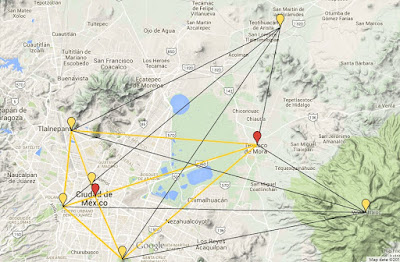
An overview of the system of alignments of ancient sites that we have discovered across the Valley of Mexico. The great Aztec capital of México-Tenochtitlan occupies the most privileged spot in this scheme, at the intersection of two major alignments. Texcoco, Chapultepec, Tenayuca and Cerro de la Estrella represent equally important focal points in the same scheme. [Reconstruction by Author, courtesy Google Maps]
                “A great, scientific instrument lies sprawled over the entire surface of the globe. At some period, thousands of years ago, almost every corner of the world was visited by people with a particular task to accomplish. With the help of some remarkable power, by which they could cut and raise enormous blocks of stone, these men created vast astronomical instruments, circles of erect pillars, pyramids, underground tunnels, cyclopean stone platforms, all linked together by a network of tracks and alignments, whose course from horizon to horizon was marked by stones, mounds and earthworks”

[John Michell, The New View over Atlantis, Thames & Hudson, Reprinted 2001]

                This is the first part of a series of articles on what will be considered by many as a very controversial subject. The topic is that of the alignment and placement of ancient sites. There are many theories and speculations on why a particular location was chosen for the placement of ancient pyramids, ancient temples and sanctuaries, ranging from Giza’s Orion correlation theory to New Age beliefs in the existence of such things as ley lines and Earth energies.

A number of studies and the advances in the still relatively new discipline of archaeoastronomy have revealed important elements of the connection between the ancients and the Sky. Nevertheless, when this approach is applied outside of a single site or landscape feature to encompass multiple ancient sites (as in the case of the Egyptian pyramids or the ancient city of Angkor, in Cambodia), the results are, at best, controversial.
Even more controversial is the idea that the placement of ancient sites, even over very long distances, would be ruled by geodetic or mathematical proportions having little or no connection at all with the local geography or other strategic reasons usually advocated for explaining the location chosen for the founding of a city or a temple.

Geodesy, that is the science of measuring of the Earth, is not something commonly ascribed to ancient civilizations. The accurate determination of latitude and longitude has only been possible in relatively modern times, with the invention of precision chronographs. While latitude can be calculated with sufficient accuracy with the help of a quadrant or astrolabe, by observing the altitude of the sun or of certain “fixed” stars above the horizon, the problem of longitude remained without a solution until the invention of the marine chronometer in 1773. [1]

Without such knowledge, establishing a “grid” or network of ancient sites over a large enough area would have been highly unpractical, if not impossible. This is why such a theory of long-distance alignments of ancient sites – which would moreover need to take into account the curvature of the Earth or some advanced surveying and projection techniques believed to be the exclusive domain of modern science -  is nowadays utterly dismissed as a wishful fantasy.

This often turns into a circular argument. Because no ancient civilization clearly possessed the scientific or technological instruments required to achieve such precision alignments, then any alignment must be the product of chance or coincidence. This is, not to speak of the reason why ancient civilizations should have deliberately placed their sacred sites along a grid or system of geodetic and landscape alignments of some sort. More on this later.

Three Pyramids and a “Star” Mountain
This was the likely aspect of the great Aztec capital of México-Tenochtitlan at the time of the arrival of the Spanish Conquistadores in 1519. A city of 250,000, larger than any Western European city at the time, built on an island in the middle of the lake of Texcoco. Its ruins lay buried underneath present day Mexico City, while even the lake has succumbed to the growth of the modern-day Mexican capital. [La Gran Tenochtitlan, original painting by Miguel Covarrubias, Museo Nacional de Antopologia, Mexico City]
                Ancient Mexico is an excellent ground for the study of ancient alignments. Not only do we find a continuity of civilization and beliefs going back thousands of years, from the Aztecs, Toltecs, Maya and Teotihuacan, down to the mysterious Olmecs; but we also find more pyramids than in any other Country in the world to verify such a theory (there are no accurate estimates, but the number might easily be in the thousands).  
The Valley of Mexico, with its vast flat plain once occupied by the ancient lake of Texcoco and surrounded by high mountains, will be the perfect setting to verify our theory of alignments.

When drawing on a map the major ancient sites around the Valley of Mexico, almost immediately an interesting pattern starts to emerge. 
There are three major Aztec pyramids within the boundaries of present day Mexico City: these are the Templo Mayor of México-Tenochtitlán, the Templo Mayor of Tlatelolco and that of Tenayuca.

All these constructions share very similar characteristics: they were built around the same time period, between the XIV and the early XVI Century AD, and were all subject at some point to Aztec rule, erected by people sharing a similar system of myths and beliefs. They all consist of a large pyramid platform, surmounted by a double sanctuary and enclosed within a sacred precinct. Let me state this again: These are the three largest pyramids within present day Mexico City, and are virtually identical in construction and design [2]; yet, no one has apparently noticed (up to this day), that they are also very precisely aligned among each other.

Let’s take a closer look:

Tenochtitlán 
A model reconstruction of the Templo Mayor of México-Tenochtitlan, from the Museo del Templo Mayor. One of the major archaeological discoveries of the 20th Century, this ancient pyramid had laid buried for almost 500 years underneath one of Mexico City's busiest squares. Excavations began in 1978, and are still ongoing. [Museo del Templo Mayor, Mexico City]
                The great Aztec capital of Tenochtitlán was built on an island in the center of the lake of Texcoco, subsequently enlarged with the construction of artificial dykes and canals. At the very center of the City, within the sacred precinct, was the great Teocalli, the Templo Mayor, with its twin sanctuaries dedicated to the gods Tlaloc and Huitzilopochtli. Built as a massive pyramid, the temple had at least seven stages of construction, dating from 1337 to 1521 AD. At its peak, the temple measured 100 by 80 meters at its base, and reached between 45 and 60 meters in height. Its impressive ruins, discovered in 1978 after centuries of abandonment and deliberate destruction, are still one of the major tourist attractions in downtown Mexico City.    

Tlatelolco
The ruins of Tlatelolco, in present day Plaza de las Tres Culturas. Archaeological excavation have revealed the main ceremonial center of the city that was the sister twin of México-Tenochtitlan and rivaled with it in power and splendor. [Photo by Author]
After the conquest, the Spanish built a large church and a convent, named after the Colegio de Santa Cruz, on the site of the former Templo Mayor of Tlatelolco. The ruins of the massive pyramid still bear evidence of several layers of construction, being almost identical to the Templo Mayor of México-Tenochtitlan. [Photo by Author]
                Tlatelolco was a sort of sister city to México-Tenochtitlán, also built on an island in the lake of Texcoco. The city itself was founded by a dissident Aztec faction only 13 years after the founding of México-Tenochtitlán, in 1338 AD. Like the Templo Mayor of its sister city, also the great pyramid of Tlatelolco underwent several construction stages – at least seven, whose imposing ruins still survive in what is today Plaza de las Tres Culturas. The last construction stage had similar dimensions to the Templo Mayor of México-Tenochtitlán, measuring some 80 by 70 meters at the base, and also included a double sanctuary at the top dedicated to the gods Tlaloc and Huitzilopochtli.  

Tenayuca
The great pyramid of Tenayuca is one of the best preserved constructions of the post-classic period in the valley of Mexico. The massive pyramid also contains the remains of at least 7 other earlier stages of construction. The great pyramid of Tenayuca, with its twin sanctuaries and double stairway is considered the prototype for both the Templo Mayor of México-Tenochtitlan and of Tlatelolco. [Photo by Author]
The base of the pyramid of Tenayuca is surrounded by a massive Coatepantli, that is, a "wall of snakes", which incorporates as much as 140 sculptured serpent heads. These sculptures were originally painted in bright colors, to indicate the different cardinal directions. [Photo by Author] 
                Tenayuca was an old settlement of the Chichimecas, whose foundation might be traced back to as early as 1064 AD. The last stage of construction of this pyramid, which was likely the prototype of all later Aztec pyramids, measured 68 by 76 meters at its base, and also underwent several stages of construction and reconstruction (at least eight). Also at Tenayuca, a twin stairway led to the double sanctuary on top of the massive pyramid.  Interestingly, the pyramid of Tenayuca does not share the same equinoctial orientation as the Templo Mayor of México-Tenochtitlán and Tlatelolco, but is rather oriented towards the setting of the star Aldebaran, in the constellation of Taurus, 17 degrees north of the ideal East-West orientation on the day of the passing of the Sun at its zenith. [3]

The Alignment Tenayuca – Tlatelolco – Tenochtitlán – Cerro de la Estrella
The main system of ancient alignments around the Templo Mayor of México-Tenochtitlan. [Reconstruction by Author, courtesy Google Maps]
                It is easy to realize that a line drawn through the summit of the Templo Mayor of México-Tenochtitlán and the Templo Mayor of Tlatelolco would terminate exactly on the main sanctuary of the pyramid of Tenayuca.

To further confirm and reinforce the existence of this alignment, it should be noted that one of the major road arteries in present day Mexico City, the Calzada Vallejo, follows exactly this same alignment between Tlatelolco and Tenayuca. This is not surprising, given that the modern road follows the track of one of the ancient causeways that crossed the – now dry - lake of Texcoco in Aztec times.

A detail of the alignment along the Calzada Vallejo, which follows a straight line that would have originally connected the Templo Mayor of México-Tenochtitlan to the great temple-pyramids of Tlatelolco and Tenayuca. Note also the right triangle formed between Chapultepec, Tenayuca and Texcoco. [Reconstruction by Author, courtesy Google Maps]
A prolongation of this alignment towards the South-East also leads to another very important landmark in Mexico City. This time, it is not a pyramid, but rather a steep, forested hill called Cerro de la Estrella. Again, this can be no chance: The Cerro de la Estrella played a very important role in the sacred geography of the Valley of Mexico, as it is the spot where the Aztecs celebrated the New Fire ceremony every 52 years, at the end of each calendar cycle and the beginning of a new one. 
The etymology of the name is unclear; Cerro de la Estrella meaning “Mountain of the Star”, supposedly after a colonial hacienda by the same name built on its slopes soon after the Spanish conquest of Mexico. The ancient name of the hill, which rises 224 meters above the surrounding plain, was Huizachtecatl, meaning a forested hill in ancient Nahuatl. Yet the highly evocative name of “Mountain of the Star” could have a much more profound astronomical significance that we do not yet fully understand.

A pyramid was built by the Aztecs on top of the Cerro de la Estrella, but the occupation of the site dates back at least 3,000 years. A large settlement occupied the slopes of the hill between 100 and 650 AD, contemporary with the rise of the power of Teotihuacan in the valley of Mexico, on the North-Western shore of the lake of Texcoco.

Interestingly, the alignment would not appear to point towards the summit of the hill, but rather deviates a couple of degrees to the West towards a little eminence on its Western slope.
In 2006, a massive pyramid was discovered on the Northern slopes of Cerro de la Estrella, measuring as much as 150 meters at its base, one wonders what might still lie buried at this fascinating site. [4]

The picture expands
The two major systems of alignments that cross modern-day Mexico City - the line Tenayuca-Tlatelolco-Tenochtitlan-Cerro de la Estrella and the line Chapultepec-Tenochtitlan-Texcoco cross at a right angle on the site of the great pyramid-temple of México-Tenochtitlán, as can be easily verified from the picture above. [Reconstruction by Author, courtesy Google Maps]
                For how interesting the alignments we have discovered so far, these would have been certainly within the technical capabilities of the Aztecs: The longest distance in the alignment, that is the one between Tenayuca and Cerro de la Estrella, is only 22.5 Km, meaning that the hill would have been within a clear line of sight connecting Tenayuca to the great temples of Tlatelolco and Tenochtitlán. This was even truer in ancient times, without the pollution and haze of modern day Mexico City.

Interestingly, the Templo Mayor of Tenochtitlan is located exactly at the same distance of 11.3 Km from Tenayuca and Cerro de la Estrella, being at the exact center of the imaginary line connecting these two points (1:1). 
And what about the position of Tlatelolco? The great pyramid of Tlatelolco is located only 1.9 Km from the Templo Mayor of Tenochtitlán. That means, Tlatelolco divides the line connecting the pyramid of Tenayuca to that of Tenochtitlán in two segments of 1.9 and 9.4 Km; the total segment length being 11.3 Km. This means that the distance Tenochtitlán-Tlatelolco is exactly 1:5 of the distance Tlatelolco-Tenayuca. 

And there is more. This first alignment Tenayuca-Tlatelolco-Tenochtitlán-Cerro de la Estrella appears to be at a right angle with another equally impressive alignment, also crossing through the Templo Mayor of México-Tenochtitlán.

The alignment Texcoco-Tenochtitlan-Chapultepec

This second alignment connects the ancient city of Texcoco to the sacred hill of Chapultepec, and in doing so crosses the axis Tenayuca-Cerro de la Estrella at a right angle exactly in its center, that is on the spot occupied by the Templo Mayor of México Tenochtitlán.

The Cerro de Chapultepec, whose summit is now occupied by the castle built for Emperor Maximilian I of Mexico in the XIX century, was considered sacred by the Aztecs. There the Aztec emperors had their baths and gardens, and a temple likely existed on the summit. Several astronomical and geodetic markers are still to be found on the high cliffs below the castle, including some fine bas-reliefs of Moctezuma II and a giant rock sculpture of a snake.

On the opposite end of the alignment, Texcoco was one of the cities of the Aztec triple alliance, together with México Tenochtitlan and Tlacopán (Tacuba). A city of the Acolhuas, Texcoco became one of the most important cities in ancient Mexico during the reign of Netzahualcoyotl, extending itself over 450 hectares on the shores of Lake Texcoco. The city became a major center of learning, and has been often described as the “Athens” of ancient America; home of poets, philosophers and astronomers, as well as to one of the largest libraries of the pre-Columbian world. The great temple of Texcoco was apparently second only to the one of México-Tenochtitlan, and the legendary palace of Netzahualcoyotl, consisting of some 300 rooms and all built of dressed stone, was still a wonder to behold at the time of Bullock’s visit in 1824. [5]  
An ancient depiction of the Templo Mayor of Texcoco, with its twin sanctuaries at the top, from the Codex Ixtlilxochitl , early 16th Century [Codex Ixtlilxochitl, fol. 112V]
Very little remains nowadays of the former glory of Texcoco. The last remnants of the great temple of Texcoco were demolished sometime around 1880 to make material for construction, but its location is accurately marked in XIX century maps at a place known as “Cerro de La Simona”, along the present day Calle Guerrero, and between the Calles Allende and Aldama. This position allows drawing a precise alignment between the Templo Mayor of Texcoco and the Templo Mayor of México-Tenochtitlan, pointing to the sacred hill of Chapultepec (itself a major natural landmark on the immediate shores of what was then the lake of Texcoco).

The alignment Texcoco-Cerro de la Estrella-Cerro del Ajusco

Something very interesting also happens when observing the alignment between Texcoco and the Cerro de la Estrella. A prolongation of this line points straight to the summit of the Ajusco; the highest peak, with its 3,930 meters, within modern Mexico City boundaries and one of the most easily recognizable landmarks in the entire valley of Mexico (its highest point, called Pico del Aguila or Eagle’s peak was considered sacred since ancient times, and does indeed resemble a giant spread eagle from the distance).

The triangle Texcoco-Teotihuacan-Mount Tlaloc

Texcoco is also at the vertex of an isosceles triangle, that if forms with the ancient sacred sites of Teotihuacan and Mount Tlaloc. The distance between Texcoco and Teotihuacan and between Texcoco and the summit of Mount Tlaloc is the same and equals 12.5 Km. This is suggestive of a system of survey points or triangulation markers.

Teotihuacan was one of the major ceremonial centers of the classic period in the valley of Mexico, a city whose influence extended as far as Guatemala and the Maya region. On the other hand, Mount Tlaloc, with its 4,151 meters, is one of the highest points in the valley of Mexico, and a sacred mountain connected with the cult of the rain-god Tlaloc. The pre-Hispanic sanctuary on its summit is believed to be the highest archaeological site in the world, and consists of an imposing platform approached by a stone causeway, from whose summit the view easily embraces the entire valley of Mexico and beyond.

Connecting the dots  
The two interconnected systems of alignments centered on the Templo Mayor of México-Tenochtitlan and on the great pyramid-temple of Texcoco. The lines in black are hypothetical lines of sight drawn from the holy city of Teotihuacan and the pre-Columbian sanctuary on the summit of Mount Tlaloc. These two points are equidistant from Texcoco. The apparently arbitrary placement of the Templo Mayor of Tlatelolco along the axis Cerro de la Estrella-Tenochtitlán-Tenayuca now becomes clear once a new line of sight is drawn from Teotihuacan to the Cerro de Chapultepec. [Reconstruction by Author, courtesy Google Maps]
After connecting all the dots, the resulting figure resembles an enormous kite, having at its four vertices the sacred sites of Texcoco, Tenayuca, Cerro de la Estrella and Chapultepec. The observation points of Cerro del Ajusco, Monte Tlaloc and Teotihuacan remain outside of this figure, but are placed symmetrically with respect to each other and to the overall figure on the ground. The Templo Mayor of México-Tenochtitlan occupies the center of this scheme, at the intersection of the two major alignments.

It is interesting to note that while the location of the great temples of Texcoco, Tenayuca, Tenochtitlan and Tlatelolco, as well as of the sacred city of Teotihuacan, reflects a deliberate artificial construction, the natural landmarks of Chapultepec, Cerro de la Estrella, Mount Tlaloc and Cerro del Ajusco are prominent landscape features over which human design could have had no role.

It was probably from the observation that the remarkable hill of Cerro de la Estrella lies virtually at the center of the triangle formed by three other major natural landmarks: the Cerro de Chapultepec, Cerro del Ajusco and Monte Tlaloc, that the position of all the other sites could be determined. 

The prominent role of Teotihuacan in this system of alignments suggests that at least part of this design might date back to the time in which the great city exerted its dominion over all of Central Mexico (that is, at least in the 2nd Century BC), a time therefore much earlier than that of the Aztecs.

The location of the great temple and the city of Texcoco was likely defined relative to that of Teotihuacan (which already existed at the time), of Mount Tlaloc, Cerro de la Estrella, Cerro del Ajusco and Chapultepec. This location is almost “miraculous” in that it is exactly equidistant between Teotihuacan and Mount Tlaloc, and is also found on the prolongation of the natural alignment between the Cerro del Ajusco and Cerro de la Estrella.

The position of the Templo Mayor of México-Tenochtitlan was subsequently defined along the line of sight between Texcoco and Chapultepec, in such a way that it would perpendicularly intersect a line drawn through the Cerro de la Estrella and to Tenayuca.

The location of Tlatelolco is even more interesting, in that it is situated along the axis Cerro de la Estrella – Tenochtitlan – Tenayuca, and also marks the point in which a line of sight drawn from Teotihuacan to the Cerro de Chapultepec intersects this latter axis.

The final picture of all the major alignments and lines of sight discussed in the present article. The major triangles and geometric figures are highlighted in different colors. The base of the triangle having Texcoco as its center (highlighted in red), marked by the axis Chapultepec-Mount Tlaloc, corresponds to the parallel of latitude at 19° 25´ North. Tenayuca and Cerro de la Estrella are also at the center of two other large triangles (in green), with the Templo Mayor of México-Tenochtitlan located at the (perpendicular) intersection of the lines connecting the centers of these 3 geometric figures. [Reconstruction by Author, courtesy Google Maps]
This systems suggests a very advanced (for the time) knowledge of cartography and trigonometry for the purpose of triangulation, and also highlights the existence of a network of alignments of sacred sites based on ancient lines of sight, which has surprisingly gone virtually unnoticed for the past 500 years. It also suggests that the location chosen for some of the major temples and ancient cities in the valley of Mexico, including the very Aztec capital of México-Tenochtitlan, is not arbitrary, but rather the product of an elaborate geodetic scheme that incorporates pre-existing natural as well as artificial landmarks. 

References

[1] The Board of Longitude, established in 1714, rewarded John Harrison for the invention of the marine chronometer in 1773. Before that, longitude could only be crudely determined with the so called “Lunar distance method”, first devised by Galileo Galilei in 1612, who noticed that the relative positions of the Moon and Jupiter could be used as a sort of universal clock; a method which however required accurate knowledge of their orbits and cycles.  
[2] The chief archaeologist and director of excavations at Tlatelolco, Salvador Guilliem, even goes to the point of suggesting that these three pyramids, those of Tlatelolco, Tenayuca and Tenochtitlán, bear such close similarities to each other that can only be explained if they were erected by the same builders.
Descubren en Tlatelolco Pirámide más antigua que Tenochtitlán, in La Jornada, 27/12/2007, accessed on-line: http://www.jornada.unam.mx/2007/12/27/index.php?section=cultura&article=a04n1cul
[3] Enrique Juan Palacios, La Orientación de la Pirámide de Tenayuca y el principio del año y siglo indígenas, Contribución al XXV Congreso de Americanistas de la Plata, Buenos Aires, 1932. Accessed on-line: http://www.revistadelauniversidad.unam.mx/ojs_rum/files/journals/1/articles/4006/public/4006-9404-1-PB.pdf
[4] Massive Ancient Pyramid Discovered in Mexico, The Guardian, 4th May, 2005. Accessed on-line: http://www.nbcnews.com/id/12173346/ns/technology_and_science-science/t/massive-ancient-pyramid-discovered-mexico/#.VaWZ2qRViko
[5] William Bullock, Six Months Residence and Travels in Mexico, London, 1824, p. 383-395