Showing posts with label Cyclopean Walls. Show all posts

Tuesday, March 9, 2021

Acatzingo de la Piedra - A monolithic pyramid in Central Mexico?

The summit of the monolithic pyramid known as the Cama de Moctezuma on the Cerro de la Malinche in Acatzingo de la Piedra, Mexico. [Photo by Author]

Acatzingo de la Piedra is an ancient fortified hilltop site in the municipality of Tenancingo, Mexico. It is located approximately 50 kilometers to the south of the state capital of Toluca and 100 kilometers to the southwest of Mexico City, near the Nevado de Toluca volcano. 

The site has never been excavated, but has been mapped and described in a 2010 publication by archaeologist Beatriz Zúñiga Bárcenas of the National Institute of Anthropology and History (INAH), and more recently by archaaeologist Vladimira Palma Linares of the UAEM Tenancingo. 

The site is one of only five known across Mexico to display significant examples of monolithic rock-cut architecture (the other four being Tezcotzingo and Malinalco, also in the state of Mexico, and the rock-cut shrines of Mazatepetl and Chapultepec in Mexico City). 

The ascent to the fortified citadel is possible through a trail that starts in the village of Acatzingo de la Piedra, along massive basalt cliffs offering breathtaking views of the valley of Toluca. The cliffs provided a natural defense for the site, and were complemented with defensive terraces and stone walls. 

The imposing basalt cliffs surrounding the site on three of its four sides. [Photo by Author]
Aerial view of the site of Acatzingo, protected by massive cliffs. [Photo by Author]

In places the exposed rock surface gives the appearance of an immense megalithic wall formed of huge cyclopean stones. The effect is indeed so strong that one wonders if some portions of the cliff face are not in fact ancient and very eroded stone walls, whose blocks appear to be carefully laid one on top of each other in regular rows. 

Is this just some strange geology or ancient megalithic stone walls? [Photo by Author]
More strange geology - Several huge stone boulders seemingly forming part a continuous megalithic stone wall. The question is - Natural or artificial? [Photo by Author] 

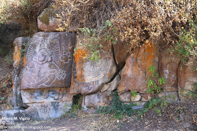
Walking along the cliff face, one passes an impressive and nearly vertical rock tower before reaching a portion of what appears to be another megalithic stone wall (or unusual geology?) on which a bas-relief of a goddess, probably Chalchiuhtlicue, but also identified with La Malinche, was carved during the Aztec (Late Post-Classic) period. The identification of the bas-relief with Chalchiuhtlicue, the goddess of terrestrial waters, seems appropriate given the presence of a natural spring gushing forth from behind the rock nearby. 

A massive rock pinnacle or tower on the approach to La Malinche. [Photo by Author]
Bas-relief carving of the goddess Chalchiuhtlicue, near a natural water spring on the Cerro de la Malinche. [Photo by Author]
A detail of the same carving with calendrical glyphs symbolically relating to the beginngin of the present World Age or Cycle and the New Fire ceremony celebrated every 52 years. [Photo by Author]
More unusual geology near the carving of the goddess Chalchiuhtlicue. The cliff face has the appearence of an ancient and very eroded megalithic wall of interlocking stone blocks. [Photo by Author]
Petroglyphs painted in white on the cliff face, including crosses and monograms, testifying to the colonial use and occupation of the site. [Photo by Author]

A perilous trail then leads along the edge of the cliff to an area of petroglyphs drawn in bright white on the rock face. The petroglyphs, mostly crosses, are almost certainly colonial in origin and do not appear to be of any great antiquity. We could not identify the location of another group of petroglyphs (these certainly prehispanic) described by Dr. Zuñiga in her 2010 paper, as the thick vegetation made the trail completely impassable.

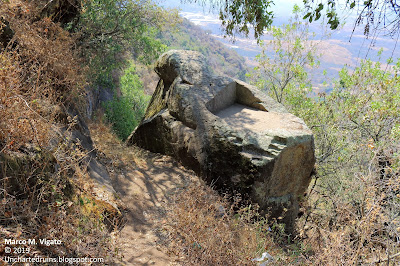
One then reaches the base of what is perhaps the most significant monument of the entire site, known as Moctezuma's bed or "Cama de Moctezuma". As seen from below, it has the appearance of a massive carved monolith of gray andesite, rising in steps towards an irregular and partially flat-topped summit. The overall shape of the rock is quite irregular, with a trapezoidal base some 15 meters wide rising in at least 5 steps that narrow towards the summit, forming narrow ledges between them.

The monolithic pyramid known as the Cama de Moctezuma as seen from the narrow trail below. [Photo by Author]
Another view of the base of the same pyramid with carved steps. [Photo by Author]
The huge carved steps forming the body of the pyramid, each between 1 and 1.5 meters high. Unfortunately the thick vegetation and proximity to the cliff face makes it difficult to have a clear view of this most unusual monument. To take this picture we had to hang over the edge of the cliff by holding on to a tree. [Photo by Author]

More carved stone steps, each about 1 meter to 1.5 meters high, are also visible on the face of another huge rock monolith located about 20 meters downhill from the level of the "Cama de Moctezuma", suggesting that this is in fact a much larger, partially buried and likely unfinished structure.

As seen from the air with the aid of a drone, the area appears almost horseshoe shaped, with the largest pyramidal monolith occupying the center of it. 

The monolith itself was apparently separated from the natural bedrock by means of a deep-cut trench with nearly vertical walls, in which additional ledges and other carved steps are visible. This trench is now entirely filled with dirt, so that it is impossible to determine at present the depth at which lies the base of the monolith, or if other carvings are present below ground level.

The top of the monolith contains a rectangular depression 1.42 wide by 2.28 meters long, deeply carved into the natural bedrock and seemingly approached by two flights of stairs placed at a ninety degree angle with respect to each other. There we measured an azimuth of 104° E, which may be of astronomical significance. 

It is possible that the entire structure was never completed and remained unfinished. It is also possible, however, that its present appearance is due to deliberate destruction during colonial times. 

The summit of the huge pyramid-shaped monolith known as the Cama de Moctezuma, showing a neatly cut rectangular hollow and two small flights of steps approaching it at a ninety degree angle. [Photo by Author]
A detail of the two badly eroded and possibly unfinished flights of stairs approaching the summit of the monolith at a ninety degree angle to each other. Note the indentations and the artificially levelled summit of the monolith. [Photo by Author]
Some more indentations or steps on one side of the monolith. [Photo by Author]
A deep rock-cut trench separates the monolith from the surrounding bedrock. [Photo by Author]
An aerial view taken from the drone of the monolithic pyramid occupying the center of a horseshoe shaped formation. Some other huge carved boulders are visible near the base of the cliff to the left and right. [Photo by Author]

About one hundred meters to the south of this rock we found another partially buried stone covered in petroglyphs belonging to different historical periods. Among them we could observe a typical Aztec round shield, or chimalli, two coyote heads, a skull, two circles, a ceremonial knife and a flower. We also observed a petroglyph containing the depiction of a horse, evidence of the late occupation of the site during the early colonial period. The area where the petroglyphs are found appears to have been used as a megalithic stone quarry, from which some huge roughly hewn boulders were extracted. In many places it is possible to observe the holes made in order to splinter the huge boulders into smaller pieces.

A huge half-buried stone covered in petroglyphs in the southern part of the site. [Photo by Author]
A colonial petroglyph containing the depiction of a horse. Unlike the other prehispanic petroglyphs, this is much shallower and was likely realized with the use of metal tools. [Photo by Author]
Aztec petroglyphs showing a skull, two coyote heads and a figure of possible astronomical significance, likely a star or a comet. [Photo by Author]
An area of the megalithic stone quarry with huge partially finished and carved stone boulders near the southern portion of the site and the petroglyph rock. [Photo by Author]

The summit of the hill was originally occupied by a set of plazas and pyramids, now entirely reduced to rubble. These structures all seemingly date to the Post-classic period and would have been still in use at the time of the Spanish conquest. 

The near flat summit of the Acatzingo hill, showing remnants of low stone platforms, mounds and retaining walls, now much destroyed and largely overgrown. [Photo by Author]

Acatzingo is a fascinating site that contains what appear to be the remnants of two different styles and possibly also different epochs of construction: One megalithic, characterized by the use of massive cyclopean stones and carved rock surfaces; the other characterized by the use of much smaller stones employed for the construction of ceremonial platforms, habitational terraces and retaining walls. 

References:

[1] Beatriz Zuñiga Barcenas, "Registro y delimitación del sitio arqueológico del cerro de La Malinche, Acatzingo de la Piedra, Tenancingo, Estado de México", Arqueología, 45, 2010, pp. 212-233.

[2] Roberto Vázquez, "Rescate de la Historia: Exploración del Sitio Arqueologico de La Malinche", Criterio Noticias, June 25, 2019. On-line resource:  "https://criterionoticias.wordpress.com/2019/06/25/rescate-de-la-historia-exploracion-del-sitio-arqueologico-la-malinche/. Las accessed March 9, 2021.

[3] Julio César Ortega Velzaquez, Descripción arquitectonica del sitio La Malinche, en el Posclásico Tardío, Tenancingo, Estado de México, UAEM Tenancingo, 2013. On-line resource: http://ri.uaemex.mx/bitstream/handle/20.500.11799/40544/TESIS.pdf?sequence=1&isAllowed=y. Last accessed March 9, 2021.

[4] Vladimira Palma Linares, "Arqueología en el sitio La Malinche", Revista Universitaria, UAEM, Vol. 2, no. 15, 2019, pp. 22-23. On-line: https://revistauniversitaria.uaemex.mx/article/view/12783/10015. Last accessed March 9, 2021. 

Sunday, February 11, 2018

The Megalithic Ruins of Ancient Mexico - Part IV

Palenque and the Megaliths of the Mayas
Palenque, one of the greatest Maya cities, lies in the foothills of the Chiapas mountains of Southern Mexico, in the basin of the Usumacinta River. Its jungle-covered ruins lay abandoned and forgotten for hundreds of years until their epic rediscovery in the 18th Century. [Photo by Author] 
Palenque is perhaps one of the better known of the ancient Maya sites, visited every year by hundreds of thousands of tourists. Located deep in the forests of Chiapas, the ancient city lay abandoned for hundreds of year until its rediscovery by Europeans in 1773. Over the following decades, it was visited by various explorers, including John Lloyd Stephens and Frederick Catherwood, who left some of the earliest drawings and plans of the ruins. Palenque reached its greatest prosperity in the late classical period during the reign of the legendary king Pakal (611-683 AD), before falling into decadence and being eventually abandoned towards the midst of the 9th Century AD. 
The ancient name of the city, as known from inscriptions, was probably Lakam Ha, meaning "Plentiful Waters". The name appears to be a reference to the many water sources and streams that surround the ancient site. The Spanish called the ruins Palenque, from the name of the nearby village of Santo Domingo del Palenque that was founded in their vicinity in the late 17th Century.  

Mythical Origins
The Palace of Palenque is a unique Maya structure., containing four major courtyards and a three-storied tower that served as an astronomical observatory. The Palace rests on a massive megalithic platform measuring some 91 by 73 meters (300 by 240 feet), pierced by a number of tunnels and underground passageways. [Photo by Author]
Although the earliest known king of Palenque, Kúk B'alam I, did not reign until 431 AD, the ruling dynasty of Palenque bolstered in inscriptions a divine origin dating back many thousands of years. The first divine ruler of Palenque known from inscriptions was the "God G1 the Elder" or Muwaan Mat, which was believed to have ascended to the throne in the year 3,309 BC (two centuries before the beginning of the present world age, in 3,114 BC, a date that also coincides with the beginning of the Maya calendar). A second divine dynasty began in 2,360 BC and comprised three more kings (known as the God G1 the Younger, God G2 and God G3).  These divine kings were thought to have come from a mysterious land called Matwiil, symbolized by a cormorant. In honor of their ancestral homeland, the rulers of Palenque of the historical period still boasted in their titles that of "Divine Matwiil Lord[1]. Nothing of this prehistoric homeland is known, but it is possible that another enigmatic place name, Tokhtan (meaning "Mist Center), similarly occurring in hieroglyphic inscriptions, may as well be associated with it.
Palenque was known in ancient times as Lakam Ha, meaning "Great Waters", due to the presence of many streams and water sources in the vicinity. The Otulum river  (here in the picture, near the archaeological site) was diverted by the ancient Maya engineers into a number of channels and underground water tunnels. [Photo by Author]
A no less interesting story of the origins of Palenque was collected from the sacred books of the Tzeltal Maya in the late 17th Century by the then Bishop of Chiapas Francisco Nuñez de la Vega. Even before the city's rediscovery, the Tzeltal tradition spoke of a great lost city built by a foreign race, the Chanes (literally "Snakes"), under the guide of a mysterious prophet called Votan, a great hero and legislator who established a great empire of the Tzeltal people called Xibalba. According to the early Mayanist Abbé Brasseur de Bourbourg, this ancient empire once covered all of Mexico and Guatemala, and had Palenque as its capital (In the the Tzeltal legend, the city is called Nachan, "City of the Snakes"). Many have seen in these legends a variation of the familiar story of Quetzalcoatl and Kukulkan, as the hero was known to the Aztec and Yucatec Mayas. Votan, like Quetzalcoatl, was said to have come from a mysterious island kingdom, located beyond the sea, to the East, known as Valum Votan. The name of the Mexican colony of this great maritime empire was Valum Chivim. According to the original manuscript in the possession of Bishop Nuñez de la Vega, called the Probanza de Votan (the "Trial of Votan"), the kingdom of Nachan was one of four tributary monarchies of Valum Votan that together formed the empire of Xibalba or Valum Chivim. To the capitals of the other three kingdoms the same manuscript gives the names of Tulan (Tula?), Mayapan and Chiquimala (near Copán). Various voyages are mentioned between Valum Votan and its colony of Valum Chivim, each under the guidance of a different Votan. During one of these voyages, a great temple was said to have been under construction on the island of Valum Votan, whose description is strongly reminiscent of the biblical Tower of Babel [2].  
Moreover, after his final voyage Votan was said to have built a "House of Darkness" on a certain river (probably the Huehuetan or the Usumacinta), where he deposited in subterranean chambers all the sacred records of its race, under charge of certain old men and priestesses [3]. In a later article we will explore the possible connections between Votan and the esoteric legends of an ancient prehistoric "Hall of Records" in the Yucatan.  

Could Valum Votan be the same as the mysterious land of Matwiil, to which the kings of Palenque traced the beginning of their first divine dynasties?  

Megalithic Foundations
Megalithic foundations near the southeastern corner of the Palace of Palenque. Many of the stones, some of which weighing several tons, appear to have been displaced from their original location. Note the fine workmanship and jointing of the stones forming the first rows, as compared to the rough masonry of smaller stones of the platforms above. [Photo by Author]  
More megalithic stonework and precision jointing inside one of the courtyards of the Palace. Some of the stones in the picture measure over 2 meters (6 feet) long. This style of megalithic architecture is in stark contrast with that of the structures above, and may belong to a much earlier epoch hinted by in mythological texts. [Photo by Author]
A stairway consisting of large and finely fitted megalithic stone blocks leads into one of the rooms of the Palace, of much cruder construction. The first step from the top is a single monolithic stone block measuring nearly 4 meters (12 feet) long. [Photo by Author]
What proof is there of a prehistoric, non-Maya origin of Palenque? Clue may come from one of the largest structures in Palenque, the Palace, and from a vast underground network of aqueducts and tunnels that may predate the construction of the Classic Maya city.

The Palace is an immense structure, rising on an artificial platform 300 feet (91 meters) long by 240 feet  (73 meters) wide. The platform itself measures nearly 30 feet (10 meters) high, and is crossed by a number of galleries and vaulted corridors. The Palace grew over time to include a number of courtyards and an astronomical observatory in the form of a three-storied tower. Although most of the construction visible today dates to the Classic period, it is possible that earlier structures were incorporated in its foundations. These structures appear to be of the megalithic type, consisting of large, finely fitted and jointed blocks of stone, quite unlike the stuccoed masonry of small cemented stones, typical of  Classic Maya architecture ,that forms the rest of the Palace structures.

A wall consisting entirely of megalithic stone blocks, some of which measuring as much as 2 meters long, forms the first tier of the South side platform of the palace. These blocks appear to have suffered significant displacement due to natural forces that have altered the straightness of the joints and caused a deformation of the edges of the wall. This is particularly puzzling given the otherwise remarkable state of preservation of the Palace and may hint to this section of the Platform belonging to an earlier stage of construction.

On the uppermost Palace platform, the lower walls delimiting Courtyard 1 are also entirely faced with large, smooth megalithic stone blocks comparable in workmanship and size to the ones in the bottom platform, and quite unlike any other of the surrounding structures. Many of the large flagstones in this area were apparently re-carved at a later time. A beautiful megalithic stairway, in a remarkable state of preservation, is also found in this area of the Palace.
Another megalithic stairway inside the Palace of Palenque. Note how many of the larger stones appear to have been placed here in secondary use, as hinted by their imperfect fitting and the use of smaller stones to create an even surface. [Photo by Author]
One of the entrances to the system of tunnels and chambers that run under the palace of Palenque. The purpose of these subterraneans is unknown, but from the remains of  stuccoed decoration it is possible to assume a ceremonial rather than utilitarian function. [Photo by Author]
A section of the water tunnel that runs parallel to the Palace, along its Western side. Where the original stone vault has collapsed, it is possible to appreciate the use of very large stones in the walls and roof of the tunnel. [Photo by Author]
A short distance from the Palace, along its Western side, more evidence of megalithic stonework can be found in the underground aqueduct that runs parallel to its base from a mountain stream located a few hundred meters to the North.

The underground aqueducts are one of the most unique characteristics of Palenque, not found at other Maya sites. The course of the river Otulum ("Fallen Stones") was deviated and channeled into an underground tunnel running for nearly 300 meters (1,000 feet) under the main plaza and portions of the Palace. This tunnel, a masterpiece of megalithic engineering, is built entirely of enormous flagstones, some of which measuring as much as 3 meters (9 feet) long, to withstand the water pressure. The peculiar architecture of the tunnel and corbelled vaulting is visible in several places where the roof has collapsed.

Another impressive stretch of aqueduct, running entirely underground, can be found in the so-called "Picota" Group, a remote group of ruined structures located in a deep forest outside of the limits of the archaeological site. Also in this case a stream was channeled into an underground tunnel that runs for 30 meters (90 feet) under a large palatial compound. Both the entrance and exit of this aqueduct are visible, built of large megalithic stone blocks. The entrance of the aqueduct, where the river goes underground, is rectangular in shape, surmounted by an immense monolithic lintel measuring as much as 4 meters (12 feet) long. The exit has a triangular profile, consisting of as many as 7 courses of megalithic stone blocks placed in a nearly semi-circular arrangement. [4]
The exit of the Picota water tunnel near Palenque, formed by at least 7 tiers of megalithic stone blocks placed in a semicircular arrangement around the triangular opening. The size of the opening barely allows for one person to walk upright during the dry season, when the water level is low. [Photo by Author]
The entrance to the Picota water tunnel, where the river goes underground. Note the enormous monolithic lintel above the entrance to the tunnel. [Photo by Author]
In some cases these stone aqueducts run underneath structures dating to the early Classic period, an evidence of their great antiquity: In 2016, it was announced that a previously unknown water tunnel was discovered under the famous Temple of the Inscriptions that houses Pakal's tomb [5]. The Temple of the Inscriptions is one of the earliest monumental structures in Palenque, dating to 683 AD, and contains within its structure the remains of earlier layers of construction. Because the newly discovered tunnels run under the Temple, their construction must predate that of the Temple itself. The absence of a connection between the tunnels and the chambers above also suggests that the existence of the tunnels may not have been known to the Maya builders.

The megalithic tunnels and foundations of Palenque are evidence of a much older origin (perhaps even pre-Maya) of the site, a possibility consistent with the content of the hieroglyphic inscriptions found at Palenque, which include a long list of pre-dynastic rulers stretching back into prehistory, and with the local traditions of the Tzeltal people speaking of the arrival of a foreign race of megalithic builders from a land beyond the Sea.

Perhaps the most interesting possibility hinted by these traditions is the existence of an ancient "Hall of Records" situated somewhere in the vicinity of Palenque, along the Mexico-Guatemala border.
In a later article, we will speculate on the possible location of this "Hall of Records" and on the possibility that it may in fact have already been found at the ancient site of Yaxchilan on the Usumacinta river.  

References:
[1] Simon Martin and Nikolai Grube, Chronicle of the Maya Kings and Queens: Deciphering the Dynasties of the Ancient Maya. Rev. ed. Thames and Hudson, London, 2008, pp. 155-159
[2] Excerpts of the now lost manuscript of the Probanza de Votan are included in the work of Dr. Paul Felix Cabrera, Description of the Ruins of an Ancient City discovered near Palenque (based on the original from Captain Antonio del Rio), London, 1822
[3] Lewis Spence, The Problem of Atlantis, London, 1924, p. 107
[4] A description of these tunnels can be found in Edwin L. Barnhart, El Proyecto de Mapeo de Palenque - Reporte de la Temporada de Campo de 1999, FAMSI, 2004
[5] https://www.theguardian.com/world/2016/jul/25/palenque-mexico-pakal-underground-water-tunnel-system

Monday, October 2, 2017

Join us on our next Expeditions

An Update on Upcoming Expeditions

The objective of this post is to share more details on some of our upcoming expeditions that may help unravel the mystery of the origins of the great and still largely unknown megalithic civilization of the Central Mexican highlands. Many of these locations are of difficult access, in remote or impervious terrain. We need motivated people to help us conduct these expeditions on the ground and document these ancient sites (with photos, videos and aerial images) – many of which have not been published before.  

Anyone interested should contact me in private at the address: unchartedruinsblog@gmail.com

Here is an initial list of sites for investigation, with some preliminary information on their significance to our quest for the lost megalithic civilization.    

1) Exploration of the Sierra de Huautla, Morelos

The construction of the walls of Chimalacatlan in an old postcard drawing [Courtesy: Mexicoenfotos.com]
We believe that the center of the megalithic civilization of ancient Mexico must be located somewhere in the still unexplored reaches of the Sierra de Huautla, a mountainous and heavily forested area to the South of the State of Morelos. This is where ancient legends located Tamoanchan, the fabulous “place of origin” of all Mesoamerican civilization – a city founded by the Gods themselves. 

In February of 2015 we explored the mysterious ruins of Chimalacatlan in the Sierra de Huautla (Link here). This is a unique megalithic site consisting of immense stone walls and platforms occupying the summit of a hill. For its cyclopean style of construction, Chimalacatlan has been compared to some of the finest megalithic constructions of Peru, and is of a type entirely unknown in Mesoamerica. The age of these ruins is unknown, but early investigators of the site conservatively situated their origin in the 1st or 2nd millennium B.C. More reports have since surfaced on the existence of more extensive structures in the mountains near the modern day town of Huaxtla. These structures have been described as clearly megalithic or cyclopean, consisting of large stone blocks measuring as much as 2 meters in length. Several pyramids, plazas and large stone walls have been reported on the site, compatible with the presence of a large city.  

The goal of the expedition will be to document and map these ruins, collect evidence for the existence of additional unexplored sites in the Sierra de Huautla and investigate their architectural analogies with other megalithic/ cyclopean structures in Mexico, Peru and elsewhere.    

Additional information from the Mexican National Institute of History and Anthropology (INAH) - Link here

2) The Lost Pyramid of Teopantepec and the “City of the Gods” on the Cerro Colorado

An illustration of the pyramid of Teopantepec, as it stood in 1807 [Dupaix, Antiquités Mexicaines, p.4, Plate 3]
In a previous article (Link here), we identified the Cerro Colorado overlooking the modern day town of Tehuacan, Puebla, as the most likely location of an ancient pyramid known from early 18th and 19th Century documents as Teopantepec (“House of God on the Mountain”). It is possible that the original structure collapsed some time after these early reports were composed, but some remains of its megalithic stone facing may still be found on the Cerro Colorado. Local traditions mention a “City of the Gods” or a “Ciudad Perdida (Lost City)” on the nearly inaccessible summit of the mountain. On the site of this supposed lost city, satellite pictures show a vast rectangular enclosure with what appear to be the remains of an ancient pyramid in the middle. 

The expedition will start from the nearby archaeological site of Tehuacan Viejo, from which a trail leads to the summit of the Cerro Colorado. It can probably be completed as a day-trip from Puebla.   

3) Acatzingo de la Piedra – A monolithic pyramid and cyclopean walls 

A short distance from the town of Malinalco (subject of another article – here), lies the town of Tenancingo and the site of Acatzingo de la Piedra. A monolithic stone pyramid has been recently found on the mountain known locally as the “Cerro de la Malinche”. The pyramid is known as the “Cama de Moctezuma”, and a number of pictures and videos of it exist over the internet. Other pictures show what appear to be portions of megalithic/ cyclopean walls partly covered by forest. 

We will use a drone to map any structures that might exist closer to the summit of the hill, as well as any visible megalithic remains. This expedition can also be completed as a day-trip from Malinalco or Mexico City.   

Additional information from the Mexican National Institute of History and Anthropology (INAH) - Link here

4) Mexico’s Marcahuasi – The Sacred Valley of Tepoztlán

A satellite view of the Valley of Tepoztlan, with the Popocatepetl volcano in the background [Courtesy Google Earth]
Unbeknown to many, the famous Peruvian explorer Daniel Ruzo, who first documented and publicized the mysterious rock sculptures on the plateau of Marcahuasi, spent the last years of his life in Mexico in what he called the “Sacred Valley of Tepoztlán”. There, he believed that rock sculptures even larger and older than those of Marcahuasi existed in the mountains surrounding the town of Tepoztlán. He documented hundreds of colossal rock sculptures, forming what he called a “hidden blueprint” or a map pointing to the location of a legendary “Hall of Records”. Since the publication of his book “El Valle Sagrado de Tepoztlán”, the valley has however failed to attract a similar interest to its Peruvian counterpart. 
   
The town of Tepoztlán, with its stunning landscapes and the enigmatic pyramid of Tepozteco, attracts thousands of tourists every year. Only very few of them, however, are aware of the research of Daniel Ruzo. The goal of our expedition will be to document many of the rock sculptures first described and photographed by Ruzo in his book, identifying signs or marks that could point to their artificial rather than natural origin. Because of the easy accessibility of Tepoztlán from Cuernavaca and Mexico City, this can also be completed through a number of day-trips from Mexico City. We will also use a drone to document the rock sculptures from the air and identify any other features not detectable from the ground. 

5) The Mysterious Rock of Apoala

The great 19th Century ethnologist and explorer Hubert H. Bancroft collected the following tradition of the “Flying Gods” of the Mixteca. After a great deluge, two gods appeared to repopulate the Earth: “They made a very sumptuous palace – a masterpiece of skill – in which they made their abode upon Earth…on the highest part of this building was an axe of copper, the edge being uppermost, and on this axe the heavens rested […] This rock and the palace of the Gods were on a mountain in the neighborhood of the town of Apoala in the province of Mixteca Alta. The rock was called ‘The Place of Heaven´, there the Gods first abode on Earth.”  [Hubert Howe Bancroft, The Native Races, Vol. IV] 

Such a rock does indeed exist in the vicinity of the modern day town of Santiago Apoala. Several deep caves associated with the legend exist in the gorges of Apoala, and a number of very curious petroglyphs and Olmec rock-reliefs (one in particular, known as the “Danzante”) are said to exist near the summit of the rock of Apoala. 

We will be looking for remains of ancient structures on or near the summit of the rock of Apoala, which may offer evidence for the existence of a “Palace of the Gods”. We will also investigate traditions of a labyrinth of ancient tunnels in a cave known locally as the “Cueva del Diablo (The Devil’s lair)”.  

Additional information and pictures can be found here.

6) An ancient obelisk and carved reliefs in Axutla, Puebla

A satellite view of the Rock of Huehuepiaxtla (Axutla, PUE), along the Rio Atoyaque [Courtesy Google Earth]
Also in the region of the Mixteca Alta, the village of Huehuepiaxtla (Axutla, PUE) is home to a colossal rocky outcrop known locally as “La Gran Peña (the great rock)”. A number of pictures have been circulating on the internet of ancient carved reliefs and stelae found in the vicinity of the mountain, containing unusual depictions of supernatural beings which were believed to inhabit its summit. It is also said that ancient structures, including a large “stone obelisk” may exist on the summit – although no documentation of these puzzling remains could be found.  

The expedition can probably be conducted as a day-trip from Puebla, with the objective of documenting many of these curious finds and confirm the existence of ancient megalithic structures near the summit of the Rock of Huehuepiaxtla.  

Additional information and pictures can be found here.

7) A journey into the Underworld of Teotihuacan

A large chamber in one of the caves that form the ancient Underworld of Teotihuacan, located a short distance to the East of the Pyramid of the Sun [Photo by Author]
There are reportedly miles of ancient tunnels and interconnected cave systems under the ancient pyramid-city of Teotihuacan. We confirmed the existence of the tunnels and explored a small portion of this labyrinthine network to the East of the pyramid of the Sun in February of 2017 (Link here). Additional tunnel entrances are reported to exist near the palatial complex of Oztoyahualco, near Acolman, on the Cerro Gordo and in the Sierra de Patlacique to the south of the ancient city (these latter apparently carved in a very hard andesite). 

Some of the tunnels are rumored to extend for many miles. Early archaeological reports speak of labyrinthine tunnels leading to vast hollowed chambers and pillared halls deep under the earth, which may have an association with the legendary Chicomoztoc, the “Place of the seven caves” considered to be the ancestral homeland from which emerged the ancestors of the Aztec tribes. 

This expedition is likely to require proper speleological equipment for the exploration of the underground passages. 

8) The mysterious subterraneans of Xochicalco

A portion of an ancient tunnel under the acropolis of Xochicalco [Photo by Author]
A number of ancient tunnels extend under the acropolis of Xochicalco, and there are also rumors of underground chambers and labyrinthine passageways running for many miles all around. Only a small portion of the tunnel system is presently open to the public (near the so-called solar observatory or “Cueva del Sol”). Other entrances can be found on the flanks of the acropolis, which lead to collapsed portions of the tunnel system (some of which we explored in April of 2017) – the tunnels are apparently very regular and are dug through a hard local kind of limestone. During the same trip we also documented large stretches of what appear to be polygonal/ cyclopean walls forming the substructure of the acropolis. The nearby Cerro de la Bodega is also said to contain a number of tunnel entrances.   

This expedition is also likely to require proper speleological equipment for the exploration of the underground passages. 

Link to a previous article on Xochicalco here

9) The Aztec sanctuary on Mount Tlaloc

A 3D reconstruction of the Aztec sanctuary on Mount Tlaloc and the "Ghost Mountain" optical illusion [Courtesy: masdemx.com]
The chief sanctuary of Tlaloc – the Aztec god of rain, was located on the mountain that bears the same name in the vicinity of Mexico City. The sanctuary on the summit, at an altitude of nearly 4,100 meters above sea level, is considered to be among the highest archaeological ruins in the world, and contains a number of significant astronomical alignments, including a long processional ramp and a ruined pyramid-observatory.

A curious optical phenomenon takes place on the summit of Mount Tlaloc during the month of February. Known as the “ghost mountain” (La Montaña fantasma), the phenomenon consists in an apparent optical mirage of a non-existing mountain in front of the peak of Mount Tlaloc.  

The hike to the summit of Mount Tlaloc does not require any special technical equipment, but one night of camping on the mountain is required.  

Additional information and pictures can be found here

10) The search for the Cross of Xaagá 

In a previous article (Link here), we described a mysterious megalithic tomb somewhere in the vicinity of Mitla. The tomb is in the shape of a cross and consists of several immense megalithic stone blocks measuring as much as 6-7 meters long. Several black and white pictures of the alleged tomb exist, dating from the early 1900’s, but its exact location has apparently been lost. If found, the tomb would be one of the largest megalithic structures in the entire American continent. The area is also characterized by the presence of rock art and cave paintings dating back thousands of years. 

One of the few existing pictures of the large cruciform tomb at Guiaroo, dating to the time of the 1902 excavations. Each one of the immense monolithic stone blocks employed in the construction measured over 6 meters long with an estimated weight of nearly 50 tons. The location of this remarkable megalithic structure has apparently been lost. [Photo Saville, 1902]
Another view of the same structure after partial excavation, taken at an angle. [Photo Saville, 1902]
An expert guide will be required for this trek, which can probably be done on horse or mule as a day trip from Oaxaca.  

Sunday, June 14, 2015

Lost Cities of the Mexican Highlands

The mysterious ruins of Chimalacatlan

      In a remote mountain region to the South of the Central Mexican state of Morelos, stand some of the most enigmatic megalithic ruins of all of Mesoamerica.

The impressive megalithic Acropolis of Chimalacatlan rises on top of a high ridge overlooking the Sierra de Huautla and the vast plains of Morelos and Guerrero. [Photo by Author]
      Mexico and Central America are rightfully famous for their impressive concentration of ancient Pre-Columbian ruins, covering a time span of several thousand years, from the Olmec civilization of the early pre-classic and formative period (1,400 BC to 400 BC), to the great Maya civilization of the lowlands of Chiapas and Guatemala (beginning 750 BC), to the bloodthirsty rituals and military organization of the great Aztec empire (1,325 AD to 1,521 AD). 
Yet, for how impressive the architectural and artistic achievements of these great Pre-Columbian civilizations (suffice to mention the great Maya pyramids, palaces and ballcourts), megalithic stone architecture seems to be largely absent from the landscape of ancient Mesoamerica.

      Certainly, many Mesoamerican civilizations were familiar with cutting and raising large stone monoliths. As an example, one could easily cite the over hundreds of stelae erected by the Mayas of the Classic Period (250 to 900 AD), some of which weighting over 60 tons [1], or the equally impressive Olmec stone heads (weighting betwen 6 and 40 tons [2]) and Aztec monoliths. The most famous Aztec monolith, the celebrated Stone of the Sun, or Piedra del Sol, now in the Museo Nacional de Antropologia in Mexico City, in fact a massive stone calendar and cosmologic monument, weights an estimate of nearly 25 tons [3]. Even more impressive, the Tlaloc monolith (originally from San Miguel Coatlinchan and now decorating a fountain outside of the same Museo Nacional de Antropologia in Mexico City), weights in excess of 168 tons and is also believed to date to the Aztec period [4].

      In spite of these astonishing feats of engineering, the use of large and often very large stones seemed to be limited to free-standing monuments, while smaller stones, adobe and concrete were the materials of choice throughout Mesoamerica for all large scale constructions and pyramids. Even the most impressive Maya pyramids, as well as the even larger pyramids at Teotihuacan and Cholula, were built almost exclusively of small, incoherent stones and adobe, mixed with concrete and stuccoed or plastered on the outside.
Unlike the Andean region of South America, with its impressive megalithic architecture as in the region of Cuzco, capital of the Inca empire, and Tiwanaku, nothing on the scale of the impressive megalithic walls and constructions of Peru seems to have ever characterized Mesoamerican architecture. 

      There is however one remarkable exception to this rule, which is as impressive in its monumentality and scale as it is also remarkably unknown to the public at large, including many of the very specialists in Mesoamerican archaeology and architecture [5]. This is the case of the megalithic platforms and walls of Chimalacatlan, in the south of Morelos and near the border with the state of Guerrero. 

"A most ancient and famous work"

      The ruins of Chimalacatlan are located within the boundaries of the municipality of Tlaquiltenango, amid the stunning natural setting of the Sierra de Huautla. 
It takes about 40 minutes to reach the tiny village of Chimalacatlan from the municipal capital of Tlaquiltenango, and during the rainy season, another 30 to 40 minutes to walk the steep and muddy trail leading up to the ruins. 

      The site lamentably lacks almost any kind of tourist infrastructure, with the exception of a decaying panel at the end of the trail, informing you that you have finally reached the site. What you will find, however, will more than compensate the effort required to get to this remote location. 

The first structured encountered on the Mesa del Venado (and the only one at least partially cleared from the thick vegetation covering the hill) is a ceremonial ballcourt resting on top of a high dry stone platform. [Photo by Author] 
A detail of the wall construction on the Mesa del Venado shows the use of mid-sized, roughly cut stones around the corners of the structures. Although of not particularly accurate workmanship, these platforms are remarkable for the use of dry, unmortared stone. [Photo by Author]
The little ceremonial ballcourt on top of the Mesa del Venado is one of the most distinctively Meso-American structures at the site, although it possibly dates to a later phase of occupation than the megalithic walls of the Acropolis, when the settlement expanded to engulf the nearby hill. [Photo by Author]
      The first ancient construction encountered on the site, occupying a plateau know as Mesa del Venado, is a vast ceremonial platform complete with a ruined pyramid, almost entirely covered by the lush tropical vegetation of the area, and a small ballcourt game. 
Here for the first time the unusual character of the ruins of Chimalacatlan starts to emerge. The ballcourt itself rests on a large platform, built with carefully arranged unmortared stones: Even though the general quality of the masonry and stone construction is quite poor, the presence of dry walls and unmortared stone construction is striking when compared to the architectural style of other nearby sites like Xochicalco. 

      The main ceremonial center of the ancient city occupies the hill right opposite to this first group of ruins, called Cerro del Venado. The trail to the top runs amidst giant cactuses and copal trees forming a scenery of stunning natural beauty in one of the largest protected areas of tropical dry forest in all of Mexico.

      The site itself is arranged on a set of dry stone platforms, placed at different levels, once connected though a system of monumental ramps and stairways of which only few sections emerge from the thick underbrush and vegetation. Unfortunately, the lower platforms are currently in a very ruinous state, still awaiting excavation and proper consolidation works. It seems, however, that the platforms formed a set of plazas at different levels, roughly following the profile of the natural elevation.

The decaying sign at the entrance of the site. You can zoom in the image to read an English and Spanish description of the ruins, as well as a map of the major structures still visible on the mountain. [Photo by Author] 
The long ascent to the Acropolis is finally compensated with the impressive sight of this megalithic stone wall, that closes the path from the lower terraces. [Photo by Author]
      It is not until one reaches the middle portion of the hill that one encounters the first spectacular examples of megalithic architecture at the site. 
The megalithic buildings consists of a set of two superimposed platforms, at slightly different elevations,only the first one of which appears to be complete on all four sides. 
The lower platform is perfectly square and measures about 40 meters on each side. Its outer walls reach at least 7 to 8 meters high at the North-West corner, and are entirely built of massive ashlars, some of which over 2,5 meters long. The construction is of remarkable quality and accuracy, consisting of several layers of carefully laid out and jointed megalithic stone blocks. 
The second platform shares the exact same characteristics of the first one, including the slightly inward-sloping walls and fine megalithic masonry. Only the main facade of the platform survives in its entirety, while the remaining sides terminate abruptly after 25 or 30 meters against the natural bedrock.

The great megalithic wall facing the ravine on the North-West side of the Acropolis. The wall continues without interruptions for a length of about 60 or 70 meters, and encircles the Acropolis on three sides (the fourth one is the natural bedrock). Some of the stones are over 2,5 meters in length and might weight in excess of 5 or 6 tons. [Photo by Author]
The point where the lower platform joins the upper megalithic platform is marked by a beautiful angle, where the wall reaches again an heigh of about 5 to 6 meters. [Photo by Author]
The height of the wall delimiting the perimeter of the second (upper) megalithic platform decreases progressively as the slope of the hill increases, until leveling down to the level of the natural bedrock. This would have made it rather unsuitable to serve a defensive purpose, and suggest instead a ritual or ceremonial use of the megalithic platform above. [Photo by Author]
      The longest continuous stretch of megalithic walls, facing a deep ravine and joining the two platforms, covers a length of about 60 or 70 meters, and forms a beautiful angle where the two platforms join at different elevations, the second (uppermost) platform being slightly larger at the base than the lower one. 

      The top of the lower platform is occupied by what appears to be a sunken patio or courtyard, a feature not uncommon at other Olmec sites in the Region (like Chalcatzingo and Teopantecuanitlan, which might provide important elements for the dating of the megalithic platforms of Chimalacatlan). The top of the uppermost platform was also artificially leveled around a natural rocky outcrop, and is occupied by several large boulders, still in the rough, which might have been intended as part of some sort of megalithic temple or construction, which was however never completed.

In this view, taken from the South-West corner of the second (uppermost) megalithic platform, the rubble filling of both platforms, behind the megalithic retaining walls, can be clearly appreciated. The top of the first (bottom) platform is occupied by a sort of sunken patio, also delimited by large megalithic blocks, which is suggestive of the ceremonial use of the site. [Photo by Author]
A detail of one of the megalithic stone blocks on the uppermost platform, measuring over 2,5 meters in length. Interestingly, most stones appear to be cracked , something which might be compatible with exposure to very intense heat. The natural erosion has also cancelled any trace of tool marks, and is itself suggestive of the high antiquity of the site. [Photo by Author]
The megalithic wall on the North-East side varies in height between 4 meters to as little as one meter, where it reaches the level of the natural bedrock. [Photo by Author]
Another view of the same North-East angle, as seen from the lower platform. Note the very accurate workmanship and placement of the megalithic stone blocks delimiting the second (upper) platform. [Photo by Author]
The center portion of the upper platform wall is composed of more irregular stone blocks, not nearly as finely jointed as the wall portions to its left and to its right. This is possibly suggestive of later repairs, or even of the presence of a doorway in this part of the wall, that was later closed. [Photo by Author]
Near the North-East corner of the second (upper) megalithic platform, the lower platform forms an angle with it that mirrors the similar angle on the North-West face of Acropolis. The lower wall here is not even one meter tall, and would have certainly served no defensive purpose. [Photo by Author]
The Western side of the Acropolis is delimited by a low wall, less than 3 meters high, which nevertheless shows some remarkably accurate megalithic construction (compare with the dry stone wall to the left, which is of much cruder construction). [Photo by Author]
Another view of the lower megalithic platform, from the North-East. It is unclear whether the wall was actually meant to be higher (as the layer of stones placed here above the level of the platform would appear to suggest), or was only meant to act as a monumental retaining wall for the platform itself. [Photo by Author]
      Above this second platform, the natural bedrock was laid barren and cut into what would appear as canals and trenches up until the top of the hill. There, the peak is occupied by a large pyramid-like structure, consisting of four super-imposed terraces, all sharing the same trapezoid shape with the exception of the top platform, which is a perfect square. From the uppermost platform, located almost at the center of a spectacular natural amphitheater of mountains, the view stretches far away to embrace the entire Sierra de Huatla and the plains of Cuernavaca. Although some larger stones were employed in the construction of this pyramid, and a few well cut stone blocks are visible on some of the terraces, the workmanship is generally poorer than the rest of the megalithic platforms, employing smaller and more irregular stones.

Above the second megalithic platform and along the rather irregular path leading up to the top of Cerro del Venado, the natural bedrock lies (perhaps artificially?) exposed. The very deep trenches and pits cut into it might not be entirely natural, and could instead be part of an abandoned attempt at sculpturing the summit of the hill into terraces. [Photo by Author]
The uppermost platforms on the Cerro del Venado, all built of smaller, less regular stones, rise directly from the natural bedrock underneath them. [Photo by Author]
The view from the top of Cerro del Venado stretches over the entire Sierra of Huautla. [Photo by Author]
The very summit of the Cerro del Venado is occupied by this massive four-tiered pyramid. Each level is trapezoidal in shape, retained by high dry-stone walls which, although lacking the megalithic precision and monumental appearance of the lower platforms, have survived remarkably intact the ravages of time over many centuries. Some larger stones of rather regular appearence, perhaps belonging to an earlier, megalithic, stage of construction, are to be found amidst the dry-stone masonry of this pyramid. [Photo by Author]
      The general feeling is that an impressive surge of construction led the unknown inhabitants of Chimalacatlan to build the massive megalithic walls and platforms that we see today, designing an entire system of terraces and platforms around the summit of the hill, only a small portion of which was however completed by the time the site was apparently abandoned. 
Construction on the site might have resumed at a much later point in time, perhaps centuries later, when the more crude constructions were added, which included the ballcourt game on the Mesa del Venado, and the terraced pyramid which occupies the summit of the hill and incorporates several partially carved megalithic blocks that were likely part of some older, perhaps unfinished structure occupying the summit.

A lost civilization?

      In spite of the little interest that currently sorrounds the ruins of Chimalacatlan and their impressive megalithic constructions, a much larger controversy was sparkled by their early discovery at the end of the XIX Century. 
Indeed, the first mention of the ruins of Chimalacatlan in the Sierra de Huautla might date back to the early times of the Spanish conquest. A passage in the Relacion Historica de la Nacion Tulteca, composed between 1600 and 1608 by Fernando de Alva Ixtlixochitl, one of the early native historians of the New Spain and descendant of the old kings of Texcoco, seems to refer to vestiges of a very similar kind to the ones of Chimalacatlan, also in the province of Cuernavaca. 

Describing some of the most ancient seats of the Toltecs, Ixtlixochitl describes the ruins in this terms:

"In Cuauhnahuac [The ancient name of what is nowadays the city and district of Cuernavaca - NdA] they built a palace with a city, a most ancient and famous work, a palace all built of large stones, of large cut stones without mortar, nor plaster, nor wood, but all of stone, carved and jointed together." [6]

Of course, the Toltecs mentioned in Ixtlixochitl's account must not be the historical Toltecs, but rather the "mythical" Toltecs, to whom all kinds of wonderful and prodigious things were attributed by the Aztecs and by the later inhabitants of the Central Mexican highlands. 

      The modern discovery of the ruins of Chimalactlan must however be attributed to a certain Don Lorenzo Castro, Cura of Tlaquiltenango, who discovered the ruins towards the end of the XIX Century. 

      The then bishop of Cuernavaca, Francisco Plancarte y Navarrete, informed of the discovery, also took a very keen interest in the enigmatic ruins of Chimalacatlan, to the point of identifying them with the long lost capital of the Olmecs, or Tamoanchan, a mythical place believed by the Aztecs to be the seat of the Mesoamerican equivalent of the Garden of Eden and the birthplace of the first Mesoamerican civilizations, if not of mankind itself [7]

      Doubtless, the links between Chimalacatlan and the Olmec civilization run much deeper than the legendary accounts, and are also stressed in a recent paper by the Mexican Instituto Nacional de Antropologia (INAH). [8]

      According to the authors, the ruins of Chimalacatlan might date to the middle Pre-Classic period, that is to say, to a time between 800 and 600 BC, due to their striking similarity with other sites in the state of Guerrero, especially with the early Olmec site of Teopantecuanitlan, where large megalithic stone blocks were also used in the construction of a set of sunken patios and courtyards. 
Other sites with megalithic stone architecture might also exist in the remote wilderness of the Sierra de Huautla, but knowledge of these sites is still very scarce. The sites of Huautla and Mesa de los Tepalcates seem to share similar architectural features with Chimalacatlan, including the use of large megalithic stone blocks measuring over 2 meters in length. As of now, however, almost no documentation exists of these sites outside of the above mentioned report.

A view of another one of the monumental platforms at Chimalacatlan, towards the summit of the Cerro del Venado. Some of the stones used in the construction are fairly large, although the workmanship is not nearly as accurate as that of the lower megalithic terraces. Similar ruins are said to exist at several other places in the remote wilderness of the Sierra de Huautla. [Photo by Author] 
Evidence of ancient quarrying at Chimalacatlan. A large rectangular block still lies in its trench next to several other ones at various stages of completion. The quarries were located uphill from the main megalithic platforms, at a distance of some one hundred meters. [Photo by Author] 
Additional quarrying is visible near the summit of the hill of Cerro del Venado. Aerial and satellite photographs do indeed show large, regular trenches cut in the natural backrock where the hill was likely intended to be cut into additional terraces and platforms, none of which was however completed at the time most monumental construction at the site suddenly ceased. [Photo by Author] 
Again near the Western side of Acropolis, the contrast between the megalithic stone wall to the right and the much cruder dry-stone wall to the left is almost suggestive of two entirely different epochs of construction. [Photo by Author]
A view of the main ceremonial stairway approaching the Acropolis from the North-West. The height of the megalithic stone wall to the left diminishes with the slope from as much as 7 to 8 meters at the North-West corner to as little as 2 meters towards the top. [Photo by Author]
      Interestingly, the very modern day name of the municipal capital of Tlaquiltenango (from the nahua, Tlakiltenamko), where the village and ruins of Chimalacatlan belong to this day, literally means "polished" or "dressed walls", with the hieroglyphic for the city name showing a set of regular, polished constructions accompanied by the depiction of a tool commonly used for polishing stone. No significant ancient remains survive in the town of Tlaquiltenango itself, except for its Franciscan (and later Dominican) convent, built in 1540 and one of the oldest still standing in the Americas, also likely built on top of Pre-Columbian ruins and re-using much of the ancient stones. 

      Still to this day, the area is filled with legends of a once large and populous city, simply known as La Ciudad Perdida - The lost City, believed to have since time immemorial vanished in the unexplored mountain ranges and ravines of the Sierra de Huautla. There are even rumors of underground tunnels and caves that would lead to the fabled lost city. One such tunnel is rumored to connect the present day convent of Santo Domingo in Tlaquiltenango to the Churches of Zacatepec, Tetelpa, Galeana, Las Bovedas and Jojutla, which also occupy the sites of former Pre-Columbian settlements.[9] 

      It is not know who the original inhabitants of Chimalacatlan and its nearby sites were, but it is very likely they imported their megalithic technique and refined architecture from some other place, perhaps from the Olmec heartland on the coast of the Gulf of Mexico. 
The absence of artifacts clearly relatable to the megalithic structures also significantly compounds the problem of the origins of their builders and the question of their date. 

References:

[1] The Quiriguà Stela E, believed to be the largest at any Maya site, measures 10.6 meters (35 ft) from the base to the top, and weights between 59 and 65 tons. Source: http://en.wikipedia.org/wiki/Maya_stelae

[2] http://en.wikipedia.org/wiki/Olmec_colossal_heads
[3] http://www.inah.gob.mx/boletin/17-arqueologia/7469-se-cumplen-224-anos-del-descubrimiento-de-la-piedra-del-sol
[4] http://www.jornada.unam.mx/2014/04/05/espectaculos/a08n1esp
[5] One of the most extensive studies of pre-Columbian architecture in Mesoamerica (Maria Teresa Uriarte, Pre-Columbian Architecture in Mesoamerica, INAH Instituto Nacional de Antropologia e Historia, 2009), fails to mention the site altogether.
[6] Fernando de Alva Ixtlixochitl, Obras Historicas, Oficina tip. de la Secretaria de Fomento, Ciudad de Mexico, 1891, p. 38
[7] Francisco Plancarte y Navarrete, Tamoanchan: El Estado de Morelos y el principio de la civilizacion, Imp. El Mensajero, Mexico, 1911
[8] Mario Cordova Tello, Juan Pablo Sereno Uribe, Sur de Morelos: Chimalacatlan, INAH, http://consejoarqueologia.inah.gob.mx/wp-content/uploads/1_proychimala.pdf
[9] Morelos Turistico, Turismo Tlaquiltenango, http://www.morelosturistico.com/espanol/pagina/z_146_Tlaquiltenango__Turismo.php