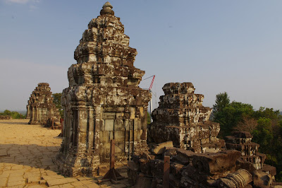
Angkor, the capital of
the great Khmer Empire between the 9th and the 14th
Century AD, was the largest city in the World of its time with a population of
over one million people. For a long time pictured as the heart of darkness in one of the 20th Century’s most gruesome
genocides, its ruins have only since a few decades resurfaced from their jungle
tomb in remote Cambodia as one of the world’s premiere tourist destinations.
The ruins of Angkor
cover an area of more than 600 Km2, a city the size of Los Angeles, larger
than New York or London, on the northern shores of Lake Tonle Sap, in what is
nowadays Cambodia. Over a span of slightly more than three centuries, over 700
temples were built within its walls, ranging from mere brick towers to gigantic
sandstone pyramids.
Ever since its
re-discovery by the Europeans in the 19th Century, Angkor has become
the archetype of the lost city, with gigantic threes looming sinisterly from
crumbling walls and cavernous temples. In fact, Angkor was never lost and
continued to remain an active site of pilgrimage for the local Buddhist
population even centuries after its collapse in the mid-14th Century.
It is true however that while a few of the major temples remained vital
throughout the Centuries; the vast majority of the ancient city was soon
reconquered by Nature and vegetation, turning much of it into a dilapidated
ruin. All in all, Angkor teaches a very interesting lesson on how quickly
nature can claim the works of man.
Angkor was forgotten – at least to the West – and even the
Khmers themselves (or their descendants), plunged into a state of barbarism
through conquest and an impoverished agriculture, seemed to retain little if no
memory of the city or its builders. Very much to the entertainment of European travelers,
they claimed the ruins had been built by Angels or by a race of giants in a
single night. Yet the great Khmer empire was no civilization of antiquity:
Angkor flourished at the same time as the European cathedrals and the remnants
of its once glorious civilization extended very much into Renaissance.
The beginnings of Angkor
are no less mysterious. A stele from Ak
Yum, near the Western Baray,
bears an inscription with a date of 713 AD by a certain Queen Jayadevi, the earliest ever found. Very
little is known of the history – let alone
the prehistory – of Angkor before its first great king, Jayavarman II,
about 802 AD. After spending much of his early life in the company of a
mysterious and powerful monarch known in Khmer inscriptions as the “King of the Mountain”, who probably
ruled from Java, Jayavarman II founded the cult of the Deva-Raja (God-King or King
of the Gods) and proclaimed himself without much modesty Chakravartin, that is “King of the World”, through a rather
obscure magical ritual performed on the sacred mountain of Phnom Kulen, some 50
Km north-East of Angkor.
Before settling in what
was to become their greatest city at Angkor, the Khmers founded several ephemeral
capitals, all within 100 Km from Angkor, as if looking for an ideal site where
to establish their capital. The first of those cities was on the Kulen
mountains. From there the capital was transferred at Indrapura (whose exact whereabouts are unknown),
and then in a new city called Hariharalaya (present day Roluos). The successors
of Jayavarman II established new cities at Yasodharapura, the first city of
Angkor, centered around the holy mountain Phnom
Bakheng, and at Koh ker under Jayavarman IV.
At the beginning of the
13th Century, the Khmer capital of Angkor Thom was surrounded by an
impressive moat running over 100 meters wide along the 9 Km walls. Two giant
reservoirs, as much as 8 by 2 Km wide, called Baray, were dug to the East and West of Angkor Thom. To the South
stood the equally impressive Angkor Wat, built by Suryavarman II as a model depiction
of Mount Meru, a temple that claimed to be the largest single religious
building on Earth.
An hypothesis that sparkled
much interest over the last decade was proposed by Graham Hancock and John Grigsby (then a Ph.D. student working for Hancock on
his book “Heaven’s Mirror”) in their stellar correlation theory with the constellation
Draco [1]. According to Hancock and Grigsby, over 15 of Angkor’s pyramids
and temples aligned with remarkable accuracy to stars in the constellation
Draco, while significant stars from neighboring constellations such as Cygnus and Corona Borealis were also marked on the ground. What was perhaps even
the more surprising was that the diagram drawn on the ground of Angkor appeared
as if turned “upside-down” with
respect to its celestial counterpart in Heaven. Hancock and Grigsby estimated this
could be due to precession and that a perfect alignment with the stars of Draco in the right position would have
only occurred before dawn on the spring Equinox around 10,450 BC; when Draco was at its lowest culmination at
Angkor. Interestingly, the great temple-pyramid of Angkor Thom, the Bayon, placed exactly in the center of
the Khmer capital and acting as the mythical omphalos or navel of the Khmer empire, would have taken the position
of the ecliptic North Pole in Hancock’s celestial diagram. [Continued in Part 2]
 |
- A plan of the city of Angkor with its major monuments - The small hilltop temples of Phnom Bok, to the North-East and Phnom Krom, to the South, are not included in the map -
|


No comments:
Post a Comment